Open this page in a new tab

Circesium

Circesium

click on image to explore this site on a new tab in Google Earth


Names
Transliterated Name Language Name
Circesium Latin
Castrum Circense Latin
Kirkēsion Greek Κιρκήσιον
Korkousiōna Greek Κορκουσιώνα
Qarqūsyōn / Qerqusion Syriac ܩܪܩܝܣܝܘܢ
Qarqisiya Arabic قرقيسياء
Qarqīsīā Arabic قَرْقيْسِياء
Qarqisyun Arabic قرقسيون
Abu Saray Arabic أبو سراي
Busayra Arabic (Modern) بصيرة
Krksyʾ Parthian
Introduction
Introduction

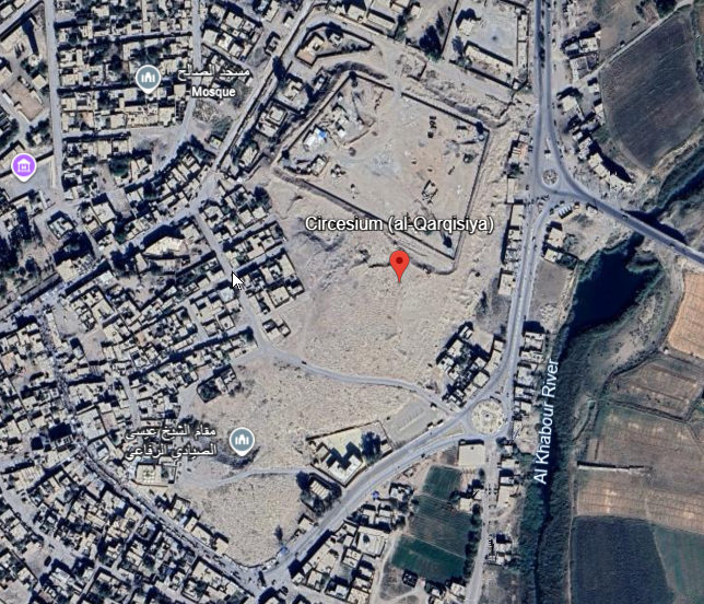
Circesium, also known as Qarqisiya, was an important frontier city and fortress at the confluence of the Euphrates and Khabur rivers in eastern Syria. Its position at the meeting point of two major waterways gave it strategic value for communication, defense, and trade, and made it a key stronghold on the Roman Empire's eastern frontier. In Late Antiquity it was one of the best known fortified places in this border zone, and later it remained significant in the early Islamic period because it lay between Syria and Iraq.

The site is generally identified with or near modern al-Busayra. Ancient and medieval forms of the name include Circesium, Qerqusion, and al-Qarqisiya, reflecting its long use in Greek, Latin, Syriac, and Arabic traditions. Syriac reference works place it among the important settlements of the Euphrates- Khabur region, while later Arabic geographical traditions also remembered its strategic setting at the river junction.

Roman emperors strengthened Circesium as a defensive outpost against the Sasanians, and it is especially associated with Late Roman and Byzantine military history. Procopius described it as the farthest fortress of the Romans, and later sources indicate that it continued to serve as a notable garrisoned site. Because of this position, Circesium belongs not only to the history of northern Mesopotamia and the Syrian Jazira, but also to the broader history of imperial frontier organization along the eastern limes.

Aerial Views
Aerial Views

Aerial Views

Normal Size

  • Circesium in Google Earth

Magnified

  • Circesium in Google Earth

Notes and Further Reading
References

Articles and Books

Barsoum, Ignatius Afram (1991) ܒܪ̈ܘܠܐ ܒܕܝܪ̈ܐ ܕܥܠ ܡܪܕܘܬ ܝܘܠܦܢ̈ܐ ܣܘܪ̈ܝܝܐ ܗܕܝܪ̈ܐ, 2nd ed., Holland: Bar Hebraeus Verlag, p. 558

Barsoum, Ignatius Afram (1987) كتاب اللؤلؤ المنثور في تاريخ العلوم والأداب السريانية, 4th ed., Holland: Bar Hebraeus Verlag, p. 518

Barsoum, Ignatius Aphram (2003) The Scattered Pearls: A History of Syriac Literature and Sciences, 2nd revised ed., Piscataway, New Jersey: Gorgias Press, p. 557

Brock, S. P. et al. (2011) Gorgias Encyclopedic Dictionary of the Syriac Heritage, Piscataway, New Jersey: Gorgias Press, Map I B2

Mladjov, I. (2018) Diachronic Maps of Syriac Cultures and Their Geographic Contexts, in King, D. and Michelson, D. A. (eds.), The Syriac World, London–New York: Routledge, maps 1, 7

Mladjov, I. (2018) Diachronic Maps of Syriac Cultures and Their Geographic Contexts, in King, D. and Michelson, D. A. (eds.), The Syriac World, London–New York: Routledge, maps 2, 7

Mladjov, I. (2018) Diachronic Maps of Syriac Cultures and Their Geographic Contexts, in King, D. and Michelson, D. A. (eds.), The Syriac World, London–New York: Routledge, maps 1, 2, 7

Potter, W. L. and Michelson, D. A. (2018) Index of Maps, in King, D. (ed.), The Syriac World, London–New York: Routledge, p. 826

Potter, W. L. and Michelson, D. A. (2018) Index of Maps, in King, D. (ed.), The Syriac World, London–New York: Routledge, p. 831

Yāqūt al-Ḥamawī (1990) معجم البلدان, Beirut: Dār al-kutub al-ʿilmiyya, vol. IV, p. 373

Wikipedia pages

Circesium