Byblos
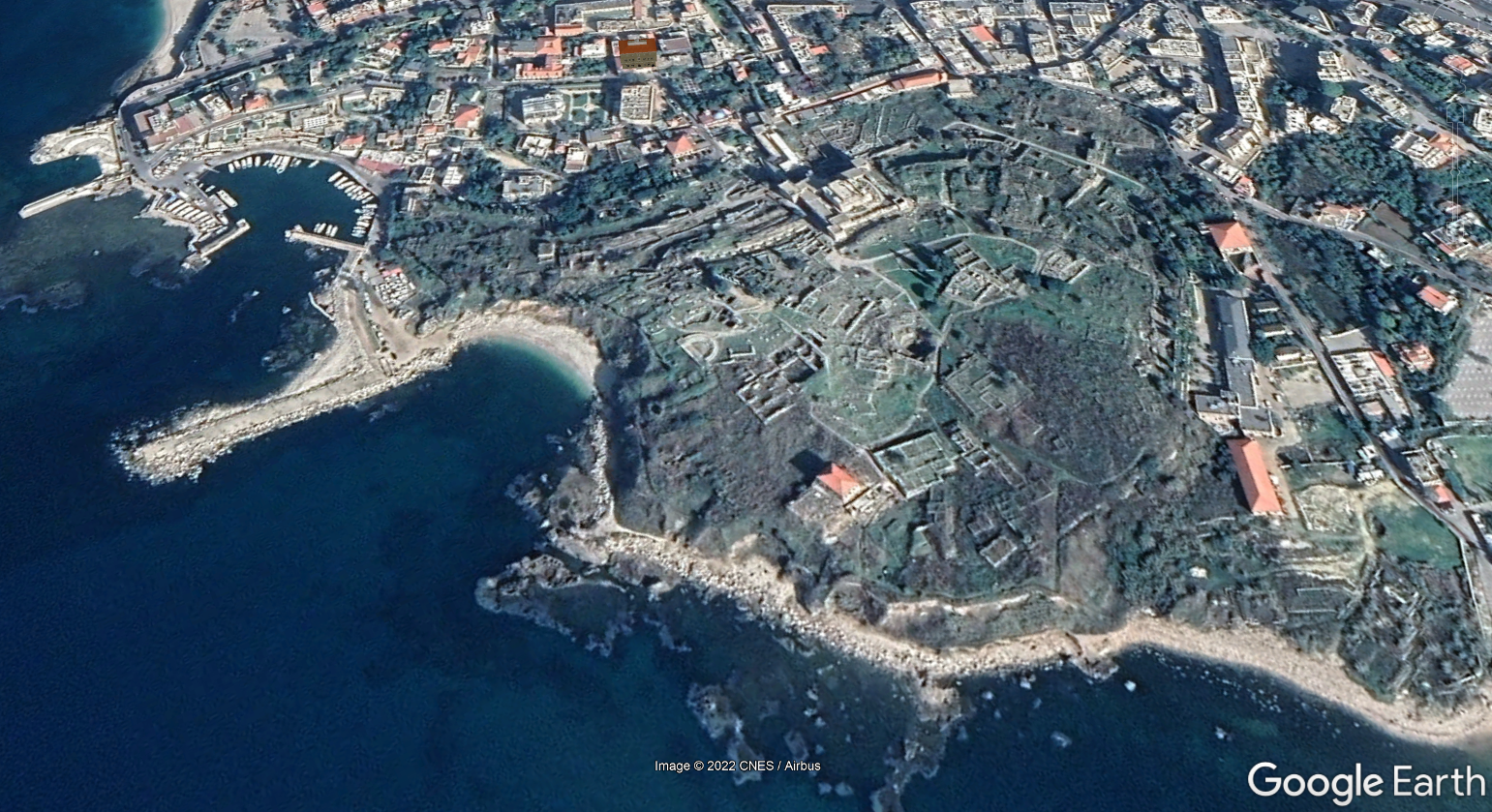 Byblos
click on image to explore this site on a new tab in Google Earth
| Transliterated Name | Source | Name |
|---|---|---|
| Bublos | Greek | Βύβλος |
| Byblus | Latin | |
| Jubayl | Arabic | جبيل |
| Jebeil | Arabic | جبيل |
| Gibelet | Crusades | |
| Giblet | Crusades | |
| gbl | Syriac | ܓܒܠ |
| Gebal | Phoenician | |
| Geval, Gebal | Hebrew Bible | גבל |
| Kebny | Egyptian hieroglyphic records going back to the 4th-dynasty pharaoh Sneferu |
|
| kbn, kpny, kbny | Egyptian | |
| Gubla | Akkadian cuneiform Amarna letters to the 18th-dynasty pharaohs Amenhotep III and IV |
|
| Gubla | Babylonian |
- Fig. 2 Simplified structural map
of Lebanon from Morhange et al (2006)
 Figure 2
Simplified structural map of Lebanon and studied sites.
Morhange et al (2006) - Byblos in Google Earth
Byblos
click on image to explore this site on a new tab in Google Earth - Fig. 3 Drawing of Raised Benches
at Ilot du Phare (Tripoli) from Morhange et al (2006)
 Figure 3
On the northern part of Ilot du Phare (Tripoli), marks of a double raised bench have been preserved. The lowest step, at approx. +1 m (above present MSL), comprises Dendropoma dated 2630 ± 35 BP (403-265 cal. BC). The outer part of the upper step, at approx. +1.2 m, has been dissected by erosion, but on the inner part, that corresponds to the base of a tidal notch, a thin cover of in situ Dendropoma petraeum shells have been collected and dated 5975 ± 40 BP (4514-4339 cal. BC).
Morhange et al (2006) - Fig. 4 Photo of raised shoreline
at Ilot du Phare from Morhange et al (2006)
 Figure 4
On Ilot du Phare, a double, stepped biological bioconstruction has been preserved on the walls of a rock fissure, at approx. +1 and +1.3 m, respectively (arrows). The upper rim could not be reached for sampling, but the two organic cornices clearly indicate, with an uncertainty of ± 0.2 m, the position of the biological sea level corresponding to two former shorelines (Photo G672). The lower rim was dated 2630 ± 35 BP (403-265 cal. BC).
Morhange et al (2006) - Panoramic View of Byblos
- Photo by Garen Bosnoyan (2022)
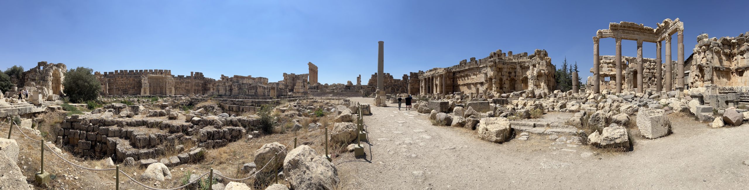 Panoramic View of Byblos
Courtesy of Garen Bosnoyan (2022)
It is an oversimplification to attribute the tsunami triggering mechanism solely to earthquake-induced seabed faulting. In some areas sediment slides may be the dominant factor of tsunami generation. In other areas, extreme storm surges leave facies which cannot be unequivocally differentiated from tsunami signatures. For example in Haifa, northern Israel a huge block was projected onto the beach during the severe storm of 2002 (Galili, pers. commun., Fig. 14). Although present day storms in the Mediterranean may displace blocks of significant size, a tsunami origin seems a feasible explanation for most of the megablocks encountered on the Lebanon coasts.
A review of the vertical movements having affected Lebanon during the late Holocene shows that tectonic uplift of the coastal areas occurred around 3000 yr BP, in the 6th century AD, and possibly in the 10th to 11th centuries AD (Pirazzoli 2005, Morhange et al., submitted). It is important to note that none of these periods coincides with the megablock dates. This suggests that they were possibly projected by waves coming from outer tsunamigenic areas. It is surprising to note that the 4th and 5th centuries AD (e.g. the tsunami of 365 AD), a period of tectonic paroxysm in the eastern Mediterranean (Pirazzoli 1986, Pirazzoli et al. 1996), are not represented by the dated megablocks.
Correlation with chronicled tsunami events is given in Table 1. Tsunami and earthquake catalogues do not provide any information on the mid-Holocene date from Ile du Palmier. Conversely, displacement of the Byblos megablocks are consistent with the 1456 AD, and 1534 or 1546 AD tsunami events, whereas the dated Senani island megablock could have been projected by any of the tsunami events reported in the area in 1752,1759,1822,1856, or 1870 AD.
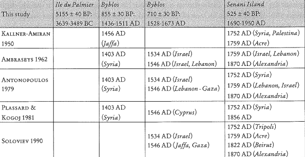 Table 1
Tentative correlation between radiocarbon dates obtained from megablocks sampled on the Lebanon coast and historical tsunamis reported by catalogues for the Eastern Mediterranean (coastal areas indicated by catalogues as tsunami-affected are added in brackets).
Morhange et al (2006)
| Effect | Location | Image(s) | Description |
|---|---|---|---|
| Coastal Uplift | Levantine Coast from Turkey to Lebanon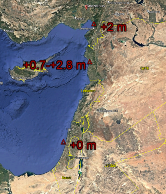 Uplift reported in Levantine Coast around 3000 yr BP (11th century BCE)
by Morhange et al. (2006a)
Uplift reported in Levantine Coast around 3000 yr BP (11th century BCE)
by Morhange et al. (2006a)Map created by JW using Google Earth Click on image to open in a new tab |
|
| Effect | Location | Image(s) | Description |
|---|---|---|---|
| Coastal Uplift | Lebanese Coast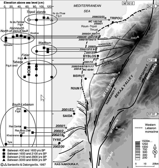 Figure 2
Structural map of Lebanon and adjacent areas. Sample locations and their corresponding elevation above sea level are shown on the left-hand side of the figure Click on image to open in a new tab Morhange et al. (2006a) |
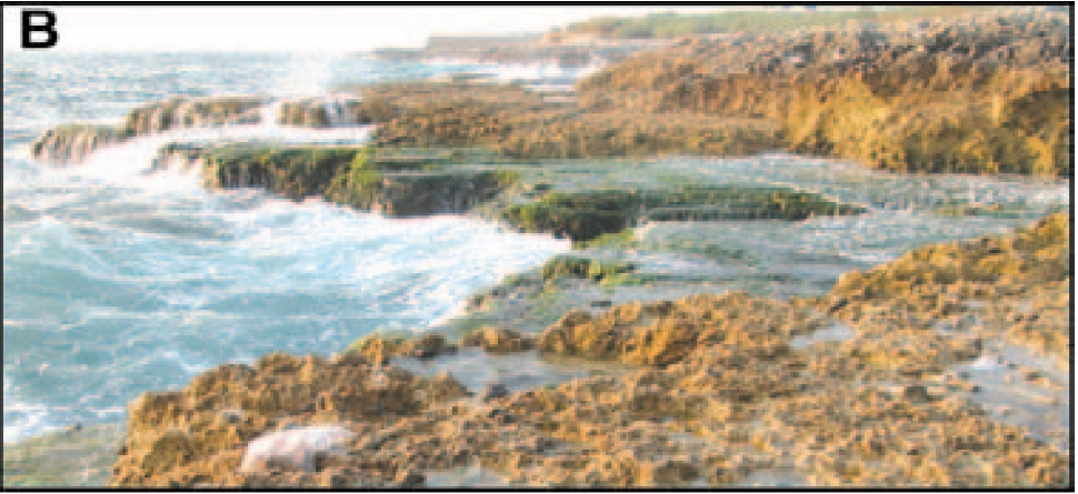 Figure 2B
Uplifted, karst-pitted vermetid benches near Tabarja. Click on image to open in a new tab Elias et al (2007) 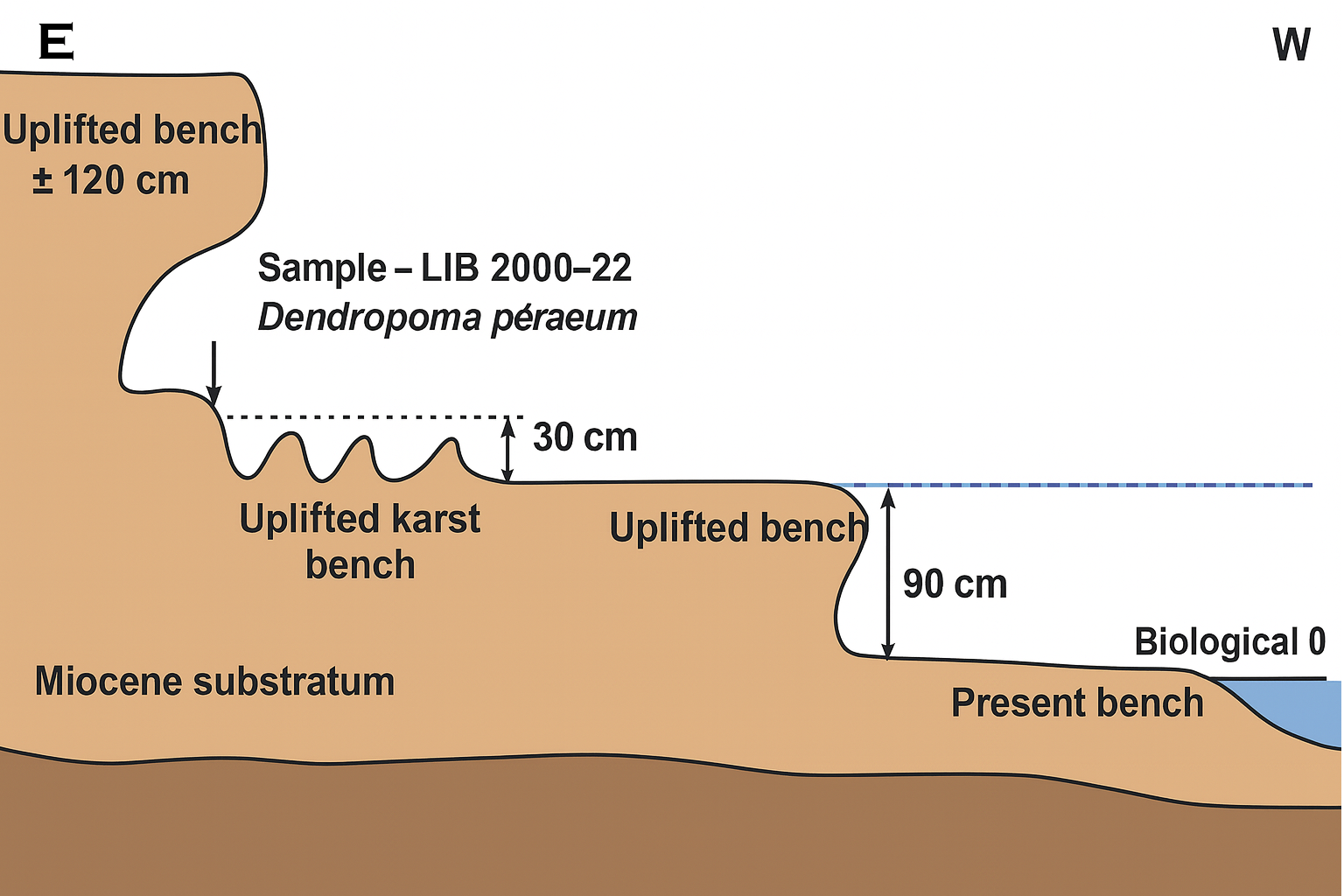 Figure 3
On the northern part of IIe du Phare (Tripoli), marks of a double raised bench have been preserved. The lowest step, at approx. +1 m (above present MSL), comprises Dendropoma dated 2630 ± 35 BP (403-265 cal. BC). The outer part of the upper step, at approx. +1.2 m, has been dissected by erosion, but on the inner part, that corresponds to the base of a tidal notch, a thin cover of in situ Dendropoma petraeum shells have been collected and dated 5975 ± 40 BP (4514-4339 cal. BC). Click on image to open in a new tab Morhange et al. (2006b) |
|
| Effect | Location | Image(s) | Description |
|---|---|---|---|
| Coastal Uplift | Lebanese and Syrian Coast
Figure 2 Structural map of Lebanon and adjacent areas. Sample locations and their corresponding elevation above sea level are shown on the left-hand side of the figure Click on image to open in a new tab Morhange et al. (2006a) |
|
- Earthquake Archeological
Effects from Rodríguez-Pascua et al (2013: 221-224)
 Earthquake Archeological
Effects Chart
Earthquake Archeological
Effects Chart
Click on image to open in a new tab
Rodríguez-Pascua et al (2013) - Simple MMI Intensity Scale
 Simple MMI Intensity
Scale
Simple MMI Intensity
Scale
Click on image to open in a new tab - More Subjective MMI Intensity Scale
 More Subjective MMI Scale
Click on image to open in a new tab
| Effect | Location | Image(s) | Description | Intensity |
|---|---|---|---|---|
|
Byblos |
|
|
- Earthquake Archeological
Effects from Rodríguez-Pascua et al (2013: 221-224)
Earthquake Archeological
Effects Chart
Click on image to open in a new tab
Rodríguez-Pascua et al (2013) - Simple MMI Intensity Scale
Simple MMI Intensity
Scale
Click on image to open in a new tab - More Subjective MMI Intensity Scale
More Subjective MMI Scale
Click on image to open in a new tab
| Effect | Location | Image(s) | Description | Intensity |
|---|---|---|---|---|
|
Byblos |
|
|
-
Earthquake Environmental
Effects (ESI 2007)
 Graphic Representation of ESI 2007 Intensity
click on image to open a higher resolution version in a new tab

| Effect | Location | Image(s) | Description | Intensity |
|---|---|---|---|---|
| Coastal Uplift | Levantine Coast from Turkey to Lebanon
Uplift reported in Levantine Coast around 3000 yr BP (11th century BCE)
by Morhange et al. (2006a) Map created by JW using Google Earth Click on image to open in a new tab |
|
VIII |
-
Earthquake Environmental
Effects (ESI 2007)
Graphic Representation of ESI 2007 Intensity
click on image to open a higher resolution version in a new tab
| Effect | Location | Image(s) | Description | Intensity |
|---|---|---|---|---|
| Coastal Uplift | Lebanese Coast
Figure 2 Structural map of Lebanon and adjacent areas. Sample locations and their corresponding elevation above sea level are shown on the left-hand side of the figure Click on image to open in a new tab Morhange et al. (2006a) |
Figure 2B Uplifted, karst-pitted vermetid benches near Tabarja. Click on image to open in a new tab Elias et al (2007)
Figure 3On the northern part of IIe du Phare (Tripoli), marks of a double raised bench have been preserved. The lowest step, at approx. +1 m (above present MSL), comprises Dendropoma dated 2630 ± 35 BP (403-265 cal. BC). The outer part of the upper step, at approx. +1.2 m, has been dissected by erosion, but on the inner part, that corresponds to the base of a tidal notch, a thin cover of in situ Dendropoma petraeum shells have been collected and dated 5975 ± 40 BP (4514-4339 cal. BC). Click on image to open in a new tab Morhange et al. (2006b) |
|
IX |
-
Earthquake Environmental
Effects (ESI 2007)
Graphic Representation of ESI 2007 Intensity
click on image to open a higher resolution version in a new tab
| Effect | Location | Image(s) | Description | Intensity |
|---|---|---|---|---|
| Coastal Uplift | Lebanese and Syrian Coast
Figure 2 Structural map of Lebanon and adjacent areas. Sample locations and their corresponding elevation above sea level are shown on the left-hand side of the figure Click on image to open in a new tab Morhange et al. (2006a) |
|
VIII |
| Description | Image | Source |
|---|---|---|
| Ilot du Palmier megablock |
 Figure 5
Ilot du Palmier is characterised by numerous megablocks, 50 to 100 m from the present coastline. The volume of the photographed megablock is approx. 3.5 m3. Superficial Dendropoma crusts yielded a radiocarbon age of 5155 ± 40 BP (3639-3489 cal. BC). Morhange et al (2006) |
Fig. 5 - Morhange et al (2006) |
| Senani island megablock |
 Figure 6
On Senani island, megablocks are scattered on the windward side. Morhange et al (2006) |
Fig. 6 - Morhange et al (2006) |
| Senani island megablock |
 Figure 7
A large tsunami block on Senani island approx. 30m3 and 10 m from the shoreline is encrusted with biological remains dated 525 ± 40 BP (1690-1950 cal. AD). Morhange et al (2006) |
Fig. 7 - Morhange et al (2006) |
| South of Enfe megablock |
 Figure 8
South of Enfe, rare cyclopean blocks arc covered by Dendropoma. Photo of a 12 m3 block radio-carbon dated to modern times (Ly 11578). Morhange et al (2006) |
Fig. 8 - Morhange et al (2006) |
| Byblos megablock |
 Figure 9
Byblos, a 5.5 m3 block projected towards the base of the ancient sea wall, encrusted with upper subtidal vermetid shells, dated 855 ± 30 yr BP (1436-1511 cal. AD). Morhange et al (2006) |
Fig. 9 - Morhange et al (2006) |
| Byblos megablock |
 Figure 10
20 m3 conglomerate block at Byblos, dated 710 ± 30 yr BP (1528-1673 cal. AD). Morhange et al (2006) |
Fig. 10 - Morhange et al (2006) |
 Table 1
14C ages of uplifted marine organisms from the Lebanese coast
click on image to open in a new tab
Morhange (2006a)