Balis

 Emar/Balis
Emar Excavation Website
| Transliterated Name | Source | Name |
|---|---|---|
| Balis | Arabic | بالس |
| Barbalissos | Medieval Greek | Βαρβαλισσός |
| Barbalisso | Tabula Peutingeriana | |
| Barbalissus | Latin | |
| Bayt Bala | Aramaic | |
| Emar | 3rd millenium BCE | |
| Qala'at Balis | Arabic | قلعة بالس |
Histories
Balis
- from Universitat Tubingen
Origins
The Arabic name Balis derives from Barbalissos, as the city was known during the Roman-Byzantine period (Barbalisso in the Tabula Peutingeriana). Barbalissos, however, was only the Greco-Roman adaptation of Aramaic Bayt Bala, a name used for the city during the time of the Achaemenid kings of Iran during the second half of the first millennium BCE. But even though these names cover almost 2000 years of the city's history, Balis/Barbalissos/Bayt Bala was nevertheless only the successor of the much older city of EMAR on the same spot the origins of which go well back into the third millennium BCE. Forty-five hundred years of settlement history--though not exactly rare in this part of the world--suggest that Emar had benefited, as did later Barbalissos/Balis, from features that did not change over the thousands of years of its existence.
This crucial element is easy to define: the Euphrates. The river not only provided for settlers the means of living, creating fertile and arable fluvial plains in the otherwise arid environment of the Syrian steppe: Balis is situated where the Euphrates, coming down from modern Turkey in the north, bends to turn towards the south-east to continue further into modern Iraq and towards the Persian Gulf.
It is easy to see that in ancient as well as medieval times, Emar/Balis would have been the place for merchants coming from the coastal cities of the Mediterranean Sea or from the north to embark on a ship bound for Mesopotamia and for cities such as Babylon or later Baghdad. Likewise caravans, coming from the south, would have followed the river up to this point and then turned west to reach the coast. The bend in the river offered another attraction for merchants and travelers as it appears that the Euphrates could be forded at a place south of the city. This ford also made the city a strategic point of first rank within Syria. It is likely that the armies of Kyros the Younger (5th century BCE) and Alexander the Great (late 4th century BCE), crossed into Mesopotamia here without having to ferry across the river. The military importance of this Euphrates crossing is mentioned directly by the Sasanian king Shahpur I in his report of his campaign against the Roman empire in 252 CE which is preserved on the Ka’aba-ye Zardusht in Naqsh-e Rostam near Persepolis:
And we annihilated a Roman force of 60,000 at Barbalissos and we burned and ravaged the province of Syria and all its dependencies […].Early Islamic Period
In 632, the first Muslim armies, moving north from Arabia had entered Syria. Damascus was conquered in 635, and two years later, Beroia (Aleppo) in northern Syria, surrendered as well. From here, a contingent of Muslim warriors under the command of Habib ibn Maslama, set out to secure the city of Barbalissos. They did not meet any resistance: the lords of Barbalissos, two Byzantine noblemen, brothers, and the city's inhabitants negotiated a truce. The treaty of surrender gave the people in the city the choice either to pay a poll-tax (in addition to the land tax) or to emigrate. The majority of Barbalissos' inhabitants opted for the latter and crossed the Euphrates into Mesopotamia or moved north to Hierapolis (Manbij) on the western banks of the river that at the time was still in the hands of the Byzantine army. To make up for the loss in population, Arab nomads from the tribe of Qays were settled in Barbalissos which soon changed its name to Balis. Thus, for a short period, Balis was once more a city on the frontier.
Balis under the Umayyad Caliphate
In the decades up to the end of the 8th century, the Byzantines were pushed back further into Anatolia while the operations of Muslim armies in Iran eliminated the threat of hostile attacks from the east that had haunted the Syrian cities along the Euphrates and on the Mediterranean coast for the first time in more than half a millennium. The new political stability led to an economic upturn in many of these formerly embattled cities, and Balis was one of them. Its strategic position on the Euphrates and proximity to the Mediterranean coast ensured its prosperity under Muslim rulers. Historical sources connect particularly the name of the general Maslama ibn 'Abd al-Malik ibn Marwan (died in 738), with a happy turn in the city's fate.
Maslama was a member of the powerful Umayyad family from Mecca which had formed the first Islamic dynasty in 660 CE. The caliphs of the Umayyad dynasty had established their capital in Damascus, the former administrative center of Byzantine Syria. Over the next decades, Syria would become the epicenter of power for the nascent Islamic world-empire, and Umayyad armies would push westward towards the Atlantic coast and Spain and eastward far into Central Asia and the Indian subcontinent.
That he had been born to a concubine and not to one of the legal wives of the caliph 'Abd al-Malik (ruled 685-705 CE), excluded Maslama from succession to the position of caliph, or "Commander of the Faithful," as the official title was. As one of the empire's top military leaders and most able administrators in the years between 705 and 730 CE, however, he would hold positions that connected him to the inner circle of power in the Umayyad state.
While neither his date of birth nor the circumstances of his youth are known, Maslama appears in historical sources for the first time in the years 705, 707 and 708 C.E. He is named, among the leaders of the annual military summer campaigns against the Byzantine borderlands, the area around the modern Turkish city Adana and the Taurus mountain range.
Convinced of his abilities in these military expeditions, the caliph Yazid entrusted him two years later (710) with the post of governor of the provinces of the Jazira (northern Mesopotamia), Armenia, and Adharbaijan, a huge responsibility, as these three provinces all bordered on non-Islamic territories. As a military leader, Maslama is best remembered for the bold, yet unsuccessful siege and sea blockade of Constantinople between 717-718 CE which ended when the plague decimated his army and superior Byzantine naval forces all but annihilated the Muslim fleet. Maslama appears to have retired from this position in 732 to return to Syria and may have lived on his estates until his death in 738.
Maslama had received Balis and its extensive countryside along the banks of the Euphrates as a fiefdom from the caliph, adding them to his increasingly large land holdings, which extended across northern Syria from the Euphrates far into the eastern Jazira. Balis itself benefited greatly from the association with arguably one of the richest and most influential men of the Umayyad polity and his family. Not only were the Justinianic city walls restored under Maslama's auspices but, more prominently mentioned in the s ources, is the enhancement of the city's importance as a merchants' entrepot by its new role as an agrarian center. Two irrigation canals, the Nahr Maslama and the Nahr Sa'id, the latter dug by Maslama's brother Sa'id ibn'Abd al-Malik not only brought drinking water to Balis from the stream that apparently had to change its course away from the city in previous centuries but must also have created new possibilities for the development of arable land on the Euphrates plains around Balis.
Since Maslama himself spent most of his time campaigning against the Byzantines or holding the position of governor in various provinces of the empire, returning to Syria only shortly before his death in 738, it was probably his brother Sa'id who, in his brother's absence, administered the town's affairs and led the branch of the Umayyad family in Balis.
Balis during the Medieval Period
After the collapse of the Umayyad state in 750 CE, Balis and its estates were taken from the Umayyad family and annexed by the new rulers, the Abbasids. At the turn of the 8th century, one of their caliphs, Harun al-Rashid, added Balis together with other northern Syrian cities such as Antioch in the west and Rusafa in the east to the Jund al-Awasim, a large province created originally to form a military buffer zone against the Byzantine north. Two hundred years later, after the Byzantine retreat to inner Anatolia, the city returned to a rather civil structure by becoming part of an administrative district with its center at Qinnasrin, south of Aleppo.
A major catastrophe hit Balis in 859 CE when an earthquake that devastated southern Turkey and northern Syria reportedly "destroyed the city." But just after having recovered from this ordeal, Balis' position as a fortress created new threats for the city's inhabitants and their financial welfare when it became the bone of contention among feuding local Muslim leaders. In the later 9th century, Balis formed the eastern outpost of the practically independent Tulunid Empire that had its center in Egypt. Plundered by a rebel army that marched against the Tulunid government in 882, Balis was still important enough to get -- at least temporarily -- its own mint and to be chosen by the Abbasid caliph al-Mu‘tadid in 900 CE as the headquarters of a planned invasion into Byzantine Cilicia.
Geographical sources of the 9th and 10th centuries mention Balis as an important stop on the way to or from Iraq; in fact, it was deemed to be the first Syrian town to be encountered when arriving from Iraq. Its size, though, may not have been as impressive as in Byzantine and early Islamic times: some of the chroniclers start calling Balis "madina saghira" "small town." Nevertheless, intellectual life was surprisingly rich for a city of modest size during these times. Biographical dictionaries list almost two dozen experts in the Islamic science of collecting and transmitting the sayings of the Prophet of Islam, Muhammad, among the inhabitants of Balis.
At the beginning of the 10th century, political circumstances threw all of Syria into turmoil and triggered a period of serious decline for the city as well. In Aleppo, the Hamdanids, a dynasty with Shi'ite leanings, established itself, which led to difficulties with Baghdad and the waning power of the Abbasid caliphs. In the same period nomads ravaged the region of the Middle Euphrates with no government in a position to check their advance effectively.
Finally, after several hundred years, the Byzantines again bring war into Muslim territory. In October of 966, Byzantine troops appeared suddenly in front of Balis' city walls and managed to capture three hundred of its inhabitants. It does not come as a surprise that trade and traffic in those times had all but subsided and Balis' reputation as an economical hub had become a thing of the past. As the 10th century geographer Ibn Hawqal writes about the city at the end of the 10th century:
Balis is a small town on the west bank of the Euphrates. It (once) was the "Port of Syria" on the Euphrates. But today its remains have been (but) gone, the caravans and traveling traders have disappeared. It is a town surrounded by a very ancient wall. In the space that separates it from the Euphrates, there are gardens. Of agricultural products, there is wheat and barley, and they produce soap in great quantities.While Balis' economic situation did not change for the better over the next century, its inhabitants, formerly Sunnites, now apparently embraced various versions of the Shi'ite creed, among them the Isma'iliya which had been championed by then for more than a century by the Fatimid dynasty ruling over Egypt and parts of Syria. Around the city limits shrines were built during this period that commemorated the Shi'ite Imams and prophetic figures.
The new, 6th/12th century CE did not provide any respite, as the fragmentation of power in Syria among several Muslim factions continued to discourage trade, formerly the city's main source of income: For groups vying for possession of the main prize, the northern Syrian metropolis of Aleppo, Balis and its fortifications became alternately the stepping stone and staging ground in the quest for Aleppo or a place to retreat and regroup after a military defeat. As a result, Balis was besieged, pillaged and again besieged, changing owners up to four times in one year. In the midst of all of this chaos, the Crusaders arrived on the scene as well: In 1110, Tancred of Antioch marched against Manbij and Balis. Their inhabitants did not wait to be killed or enslaved, the choice offered to other cities in Tancred's way, but chose to flee. The Crusaders found both cities empty and retreated to their own territory. Thirty years later, however, the Crusader state of Edessa (modern Urfa in southern Turkey) managed to conquer and hold Balis for a short period of time.
The stabilization of politics in the Levant under the auspices of first the Zengids, followed by Saladin and the Aiyubids in the 12th and 13th centuries CE would finally bring something close to a renaissance for Balis. Its population at this time consisted of "a mix of Arabs and non-Arabs" (probably Turks) and it was home to small religious minorities, Christians and Jews. The city and its hinterland became again important enough to be given as a fiefdom to princes of the ruling dynasty. In addition to makeshift repairs to older structures, new building projects such as a theological school (second half of the 12th century), a minaret for the Great Mosque (1211), and a new canal (mid-13th century) testify that investments in the battered city were again deemed to be worthwhile.
This brief period of prosperity, expansion and retrieval of its former status was, however, only the prelude to Balis' final chapter: the Mongol armies of Jengiz Khan had been moving steadily westward from Central Asia since the 1220s. In 1258 Baghdad was taken and the last Abbasid caliph killed. The next year, the Mongol general Kitbogha Noyan set out to conquer the Levant. The fact that the Mongol army began the siege of Aleppo in January of 1260 must mean that it had arrived at Balis shortly before that date, probably in the winter of 1259. Archaeological research has shown that there had been no attempts to defend the city, and only minor destruction took place. Small cashes of objects hidden under flagstones in courtyards and houses further suggest that the inhabitants fled with the intention of returning one day. They never came back, of course, and Balis slowly became a field of ruins.
André Raymond and Jean-Louis Paillet, Bâlis II. Histoire de Bâlis et fouilles deîlots I and II , (Damascus 1995).
Ibn 'As âkir, Ali ibn al-Hasan, Ta'rikh madinat Dimashq, 19 vols. (Amman 1980)
Emar
The ancient near eastern town of Emar/Imar was situated on the middle Euphrates in northwest Syria, about 100 km east of Aleppo. Due to its geographical situation connecting Mesopotamia with the Mediterranean coast and with Anatolia, the town had a strategic function. Already the earliest mentionings in writing, namely in the palace archives of Ebla, ca. 2500 BC, and especially in the Mari texts from the 18th century BC, point to the town’s importance as traffic junction and contact zone between the Assyro-Babylonian and the Syro-Anatolian cultural spheres.
Contrary to its importance as a commercial center, Emar was never the center of a supra-regional power, but was rather awkwardly positioned between rivaling states. The history of Emar can be followed down to the middle of the third millennium BC, or, in archeological terms, down to the Early Bronze Age, when the town came under the influence of the rulers of Ebla and was mentioned in their archives at several instances. Later news appear in the Mari texts (18th century BC, Middle Bronze Age) according to which Emar was under the influence of the neighboring state of Yamhad. For the 13th and the early 12th centuries BC (the Late Bronze Age), there is written documentation from Emar itself and also references in contemporaneous texts from Boğazköy/Hattuša, Ras Shamra/Ugarit and from Assyria. At that time, the town was part of the Hittite Empire, situated close to the frontier of the rivaling state of Assyria. Emar was subject to the king of Karkamiš, who represented the Hittite ruler in Syria, a member of the Hittite royal family and the connecting link between Hattuša the Hittite capital in central Anatolia, and the Syrian “vassal states”.
The Late Bronze Age town was excavated by a French team in the 1970s. Occupation layers of the Middle and Early Bronze Ages were brought to light by recent Syrian-German excavations. Archeological as well as written documentation come to an end in the second third of the 12th century BC. The site was resettled on a larger scale in Byzantine times, only.
Up to now, we know of ca. 1,170 cuneiform texts from Emar. They are, with those from Ugarit, Mari and Ebla, among the most important tablet finds in Syria. About 800 texts come from the French excavations, the rest have turned up in the art market. The large majority is written in Akkadian. Besides, there are about 100 Hurrian texts (still unpublished) and two Hittite letters. Other than in the towns of Ugarit, Mari and Ebla, where most texts belong to the palace archives, the Emar texts have mainly been found in private houses. They are, above all, judicial records – concerning, for example, dealings in real estate, marriages, last wills, adoptions – illustrating the private life of the population and, at the same time, showing the consequences of the Hittite conquest for the training of scribes and for society, in general. In the house of a priest, the so-called Temple du Devin (M1), a library was found containing, besides literary and lexical texts in the Mesopotamian tradition, ritual texts for local cults. Particularly noteworthy is the ritual for the installation of the priestess of the weathergod Ba’al of which there exist several copies.
Description from Wikipedia
- from Wikipedia
In the summer of 2002 and again with the financial support of the Ministry of Foreign Affairs, the northern bank was strengthened, the dangerous gap at the corner of the praetorium was filled and the façade covered with tiles baked in the traditional way. At the same time, the documentation of the ruin, financed by the University of Tübingen, was completed: an object of cultural heritage has been preserved, in reality and in scientific documentation.
Aerial Views, Plans, and Photos
Aerial Views
- Emar/Balis in Google Earth
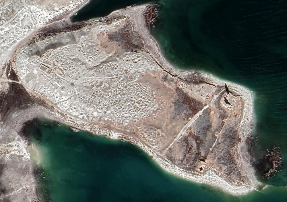 Emar/Balis
click on image to explore this site on a new tab in Google Earth
Plans
Site Plans
Normal Size
- Emar Site Plan from
Emar Excavation website
 Emar Site Plan
Emar Excavation website - Emar and Balis Site Plan
from Emar Excavation website
 Emar and BalisSite Plan
Emar Excavation website
Magnified
- Emar Site Plan from
Emar Excavation website
Site Plan
Emar Excavation website - Emar and Balis Site Plan
from Emar Excavation website
Emar and BalisSite Plan
Emar Excavation website
Photos
- Byzantine Tower at Balis
from wikipedia
 >Byzantine Tower at Balis
Click on image to view at a higher resolution in a new tab
Wikipedia - James Gordon - CC BY 2.0

1114 CE Marash Earthquake
Discussion
1114 CE Marash Earthquake
| Effect | Location | Image(s) | Description |
|---|---|---|---|
|
Balis |
|
1114 CE Marash Earthquake
- Earthquake Archeological Effects chart
of Rodríguez-Pascua et al (2013: 221-224)
 Earthquake Archeological Effects (EAE)
click on image to open a higher resolution version in a new tab
Rodríguez-Pascua et al (2013: 221-224)
| Effect | Location | Image(s) | Description | Intensity |
|---|---|---|---|---|
|
Balis |
|
|
References
Articles and Books
Excavation Reports
References from Wikipedia
- from Wikipedia
- Westenholz, Joan (2000). Cuniform Inscriptions in the Collection of the Bible Lands Museum Jerusalem: The Emar Tabltes. Styx. pp. 121, 129.
- Jean-Claude Margueron and Veronica Boutte, "Emar, Capital of Aštata in the Fourteenth Century BCE" The Biblical Archaeologist 58.3 (September 1995:126-138); a single Old Babylonian tablet was recovered.
- Adamthwaite (2001)
- Daniel Arnaud, Les textes d'Emar et la chronologie de la fin du Bronze Recent, Syria, vol. 52, pp. 88-89, 1975
- Margueron published findings at Emar between 1975 and 1990, beginning with "Les fouilles françaises de Meskéné-Emar", in Comptes-rendus de l'Académie des Inscriptions et Belle-Lettres 1975:201-213; Daniel Arnaud published the cuneiform texts, 1985-87.
- U. Finkbeiner, Emar & Balis 1996-1998. Preliminary Report of the Joint Syrian-German Excavations with the Collaboration of Princeton University, Berytus, vol. 44, pp.5-34, 2000
- U. Finkbeiner and F. Sakal, Emar after the closure of the Tabqa Dam - The Syrian-German Excavations 1996 - 2002. Volume I: Late Roman and Medieval Cemeteries and Environmental Studies, Brepols, 2010, ISBN 2-503-53320-5
- Adamthwaite, Murray R. (2001). Late Hittite Emar: The Chronology, Synchronisms, and Socio-Political Aspects of a Late Bronze Age Fortress Town. Peeters. ISBN 90-429-0909-9.
- Arnaud, Daniel, Emar: Récherches au pays d'Aştata VI: Textes sumériens et akkadiens, Erc/Adpf, 1987, ISBN 2-86538-178-1
- D. Beyer, Meskene-Emar. Dix ans de travaux 1972-1982, Editions Recherche sur les Civilisations, 1982, ISBN 2-86538-044-0
- Chavalas, Mark William,Emar: the history, religion, and culture of a Syrian town in the late Bronze Age, CDL Press, 1996, ISBN 1-883053-18-8
- D'Alfonso, Lorenzo, Yoram Cohen Dietrich Sürenhagen, The City of Emar Among the Late Bronze Age Empires, Eisenbrauns, 2008, ISBN 3-86835-006-3
- Dalley, Stephanie and Beatrice Teissier, Tablets from the Vicinity of Emar and Elsewhere, Iraq, vol. 54, pp. 83–111, 1992
- Yoram Cohen, The Scribes and Scholars of the City of Emar in the Late Bronze Age, Eisenbrauns, 2009, ISBN 1-57506-931-8
- Fleming, Daniel E., Time at Emar: The Cultic Calendar and the Rituals from the Diviner's Archive, Mesopotamian Civilizations 11, Jerrold S. Cooper ed. Winona Lake, Ind.: Eisenbrauns, 2000.
- Fleming, Daniel E., The Installation of Baal's High Priestess at Emar: A Window on Ancient Syrian Religion, Harvard Semitic Studies 42. Atlanta: Scholars Press, 1992.
- Eugen J. Pentiuc, West Semitic Vocabulary in the Akkadian Texts from Emar (Harvard Semitic Studies), Eisenbrauns, 2001, ISBN 1-57506-910-5
- Joan Goodnick Westenholz, Cuniform Inscriptions in the Collection of the Bible Lands Museum Jerusalem: The Emar Tabltes, Styx, 2000, ISBN 9056930230
Literature from Emar Excavation Website
| Adamthwaite, M. R. | Late Hittite Emar: The Chronology, Synchronisms, and Socio-Political Aspects of a Late Bronze Age Fortress Town, Louvain, 2001 (Ancient Near Eastern Studies Supplement Series 8). |
| Archi, A. | Imâr au IIIème millénnaire d'après les archives d'Ebla, MARI, Annales de Recherches Interdisciplinaires 6, 1990, 21-38. |
| Arnaud, D. | Traditions urbains et influences semi-nomades à Emar, à l'âge du Bronze Récent, in: J.-C. Margueron (Hrsg.), Le Moyen-Euphrate: zone de contacts et d'échanges, Leiden, 1980, 245-264. |
| Humbles et superbes à Emar (Syrie) à la fin de l'âge du Bronze Récent, in: A. Caquot - M. Delcor (Hrsg.), Mélanges bibliques et orientaux en l'honneur de M. Henri Cazelles, Neukirchen-Vluyn, 1981, 1-14 (Alter Orient und Altes Testament 212). | |
| Recherches au pays d'Aštata. Emar VI/1-2: Textes sumériens et accadiens. Planches, Paris, 1985 (Éditions Recherche sur les Civilisations "Synthèse" n° 18). | |
| Recherches au pays d'Aštata. Emar VI/3: Textes sumériens et accadiens. Texte, Paris, 1986 (Éditions Recherche sur les Civilisations "Synthèse" n° 18). | |
| Recherches au pays d'Aštata. Emar VI/4: Textes de la bibliothèque. Transcriptions et traductions, Paris, 1987 (Éditions Recherche sur les Civilisations "Synthèse" n° 28). | |
| Les hittites sur le Moyen-Euphrate: protecteurs et indigènes, Hethitica 8, 1987, 9-27. | |
| Textes syriens de l'âge du Bronze récent, Barcelona, 1991 (Aula Orientalis-Supplementa 1). | |
| Beckman, G. M. | Hittite administration in Syria in the light of the texts from Hattuša, Ugarit and Emar, in: M. W. Chavalas - J. L. Hayes (Hrsg.), New Horizons in the Study of Ancient Syria, Malibu, 1992, 41-49 (Bibliotheca Mesopotamica 25). |
| Hittite provincial administration in Anatolia and Syria: the view from Maşat and Emar, in: O. Carruba - M. Giorgieri - Cl. Mora (Hrsg.), Atti del II. Congresso Internazionale di Hittitologia, Pavia, 1995, 19-37 (Studia Mediterranea 9). | |
| Texts from the Vicinity of Emar, Padova, 1996. | |
| Emar and its archives, in: M. W. Chavalas, (Hrsg.), Emar: The History, Religion, and Culture of a Syrian Town in the Late Bronze Age, Bethesda, Maryland, 1996, 1-12. | |
| Family values on the middle Euphrates in the thirteenth century B.C.E., in: M. W. Chavalas (Hrsg.), Emar: The History, Religion, and Culture of a Syrian Town in the Late Bronze Age, Bethesda, Maryland, 1996, 57-79. | |
| Real property sales at Emar, in: G. D. Young - M. W. Chavalas - R. E. Averbeck (Hrsg.), Crossing Boundaries and Linking Horizons. Studies in Honor of Michael C. Astour on His 80th Birthday, Bethesda, Maryland, 1997, 95-120. | |
| Bellotto, N. | I LÚ.MEŠ.ah-hi-a a Emar, Altorientalische Forschungen 22, 1995, 210-228. |
| La struttura familiare a Emar: alcune osservazioni preliminari, in: E. Rova (Hrsg.), Patavina orientalia selecta, Padova, 2000, 187-198. | |
| Ben-Barak, Z. | The legal status of the daughter as heir in Nuzi and Emar, in: M. Heltzer - E. Lipiński (Hrsg.), Society and Economy in the Eastern Mediterranean (c. 1500-1000 B.C.), Louvain, 1988, 87-97 (Orientalia Lovaniensia Analecta 23). |
| Beyer, D. | Emar IV - Les sceaux. Mission archéologique de Meskéné-Emar. Recherches au pays d'Aštata, Freiburg (Schweiz), 2001 (Orbis Biblicus et Orientalis, Series Archaeologica 20). |
| Beyer, D. (Hrsg.) | Meskéné-Emar: Dix ans de travaux 1972-1982, Paris, 1982. |
| Chavalas, M. W. (Hrsg.) | Emar: The History, Religion, and Culture of a Syrian Town in the Late Bronze Age, Bethesda, Maryland, 1996. |
| Civil, M. | The texts from Meskene-Emar, Aula Orientalis 7, 1989, 5-25. |
| Dietrich, M. | Das Einsetzungsritual der Entu von Emar (Emar VI/3, 369), Ugarit-Forschungen 21, 1989, 47-100. |
| Die akkadischen Texte der Archive und Bibliotheken von Emar, Ugarit-Forschungen, 1990, 25-48. | |
| Der Dialog zwischen Šūpē-amēli und seinem "Vater". Die Tradition babylonischer Weisheitssprüche im Westen, mit einem Anhang von G. Keydana, Die hethitische Version, Ugarit-Forschungen F 23, 1991, 33-68 und 69-74. | |
| bulut bēlī "Lebe, mein König!" Ein Krönungshymnus aus Emar und Ugarit und sein Verhältnis zu mesopotamischen und westlichen Inthronisationsliedern, Ugarit-Forschungen 30, 1998, 155-200. | |
| Dietrich, M. - Loretz, O. - Mayer, W. | Sikkanum "Betyle", Ugarit-Forschungen 21, 1989, 133-139. |
| Durand J.-M. | La cité-état d'Imâr à l'époque des rois de Mari, MARI, Annales de Recherches Interdisciplinaires 6, 1990, 39-92. |
| Faist, B. - Finkbeiner, U. | Emar. Eine syrische Stadt unter hethitischer Herrschaft, in: Die Hethiter und ihr Reich. Das Volk der 1000 Götter, Ausstellungskatalog, hrsg. von der Kunst- und Ausstellungshalle der Bundesrepublik Deutschland, Bonn, 2002, 190-195. |
| Fales, F. M. | Notes on the royal family of Emar, in: D. Charpin - F. Joannès (Hrsg.), Marchands, diplomates et empereurs. Études sur la civilisation mésopotamienne offerts à P. Garelli, Paris, 1991, 81-90. |
| Finet, A. | Le port d'Emar sur l'Euphrate, entre le royaume de Mari et le pays de Canaan, in: E. Lipiński (Hrsg.), The Land of Israel. Cross-Roads of Civilizations, Louvain, 1985, 27-38. |
| Finkbeiner, U. | Emar 1999. - Bericht über die 3. Kampagne der syrisch-deutschen Ausgrabungen, Baghdader Mitteilungen 32, 2001, 41-120. |
| Emar 2001. - Bericht über die 4. Kampagne der syrisch-deutschen Ausgrabungen, Baghdader Mitteilungen 33, 2002,109-146. | |
| A room inventory of Early Bronze IV from Emar. Beitrag zum Kolloquium “From Relative Chronology to Absolute Chronology: The Second Millennium BC in Syria–Palestine”, Rome 29. November – 1. Dezember 2001, (im Druck). | |
| Finkbeiner, U. - Leisten, T. | Emar & Bālis 1996-1998. Preliminary report of the joint Syrian-German excavations with the collaboration of Princeton University. I. Emar 1996-1998, Berytus 44, 1999-2000, 5-34. |
| Finkbeiner, U. - Sakal, F. | Emar 2002. - Bericht über die 5. Kampagne der syrisch-deutschen Ausgrabungen, Baghdader Mitteilungen 34, 2003, 9-117. |
| Fleming, D. E. | A limited kingship: Late Bronze Emar in ancient Syria, Ugarit-Forschungen 24, 1992, 59-71. |
| The Installation of Baal's High Priestess at Emar. A Window on Ancient Syrian Religion, Atlanta, 1992 (Harvard Semitic Studies 42). | |
| The rituals from Emar: evolution of an indigenous tradition in second-millennium Syria, in: M. W. Chavalas - J. L. Hayes (Hrsg.), New Horizons in the Study of Ancient Syria, Malibu, 1992, 51-61. | |
| The etymological origins of the Hebrew nābî’: the one who invokes God, The Catholic Biblical Quarterly 55, 1993, 217-224. | |
| More help from Syria: introducing Emar to Biblical study, Biblical Archaeologist 58, 1995, 139-147. | |
| The Emar festivals: city unity and Syrian identity under Hittite hegemony, in: M. W. Chavalas (Hrsg.), Emar: The History, Religion, and Culture of a Syrian Town in the Late Bronze Age, Bethesda, Maryland, 1996, 81-121. | |
| Rituals from Emar, in: W. W. Hallo (Hrsg.), The Context of Scripture. Vol. I: Canonical Compositions from the Biblical World, Leiden, 1997, 427-443. | |
| Time at Emar. The Cultic Calendar and the Rituals from the Diviner's Archive, Winona Lake, 2000 (Mesopotamian Civilizations 11). | |
| Grosz, K. | Daughters adopted as sons at Nuzi and Emar, in: J.-M. Durand (Hrsg.), La femme dans le Proche-Oriente antique, Paris, 1987, 81-86. |
| Gündem, C. Y. - Uerpmann, H.-P. | Erste Beobachtungen an den Tierknochenfunde aus Emar (Syrien) - Grabungen bis 2002, BaM 34, 2003, 119 -128. |
| Hess, R. S. | A comparison of the Ugarit, Emar and Alalakh archives, in: N. Wyatt - W. G. E. Watson - J. B. Lloyd (Hrsg.), Ugarit, Religion and Culture. Essays Presented in Honour of Professor John C. L. Gibson, Münster, 1996, 75-83. |
| Hoskisson, J. P. | Emar as an empirical model of the transmission of the canon, in: K. L. Younger - W. W. Hallo - B. Batto (Hrsg.), Scripture as Canon IV: The Biblical Canon in Comparative Perspective, Lewiston, 1991, 21-32. |
| Ikeda, J. | The Akkadian language of Emar: texts related to Ninurta and the elders, Acta Sumerologica 19, 1997, 83-112. |
| The Akkadian language of Emar: texts related to a diviner's family, in: Sh. Izre'el - I. Singer - R. Zadok (Hrsg.), Past Links. Studies in the Languages and Cultures of the Ancient Near East, Winona Lake, Indiana, 1998, 33-61 (Israel Oriental Studies XVIII). | |
| The Akkadian language of Carchemish: evidence from Emar and its vicinities, Acta Sumerologica 20, 1998, 23-62. | |
| Scribes in Emar, in: K. Watanabe (Hrsg.), Priests and Officials in the Ancient Near East, Heidelberg, 1999, 163-185. | |
| Kämmerer, T. R. | Zur sozialen Stellung der Frau in Emār und Ekalte als Witwe und Waise, Ugarit-Forschungen 26, 1994, 169-208. |
| Leemans, W. F. | Aperçu sur les textes juridiques d'Emar, Journal of Economic and Social History of the Orient 31, 1988, 207-242. |
| Le droit d'Emar, ville sur le Moyen-Euphrate, au XIIIe siècle av. J.-Chr., Oosters Genootschap in Nederland 19, 1992, 3-33. | |
| Margueron, J.-C. | Emar: un example d'implantation hittite en terre syrienne, in: J.-Cl. Margueron (Hrsg.), Le moyen Euphrate: zone de contacts et d'échanges, Leiden, 1980, 285-314. |
| Meskene (Imar*/Emar). B. Archäologisch, Reallexikon der Assyriologie 8, 1993, 84-93. | |
| Moor, J. C. de | Standing stones and ancestors worship, Ugarit-Forschungen 27, 1995, 1-20. |
| Morrissette, J. | La place des femmes dans la famille: succession et héritage à Emar, Bulletin. Canadian Society for Mesopotamian Studies 26, 1993, 23-27. |
| Pentiuc, E. J. | West Semitic Vocabulary in the Akkadian Texts from Emar, Winona Lake, Indiana, 2001 (Harvard Semitic Studies 49). |
| Pitard, W. T. | Care of the dead at Emar, in: M. W. Chavalas, (Hrsg.), Emar: The History, Religion, and Culture of a Syrian Town in the Late Bronze Age, Bethesda, Maryland, 1996, 123-140. |
| Schmidt, B. B. | The Gods and the dead of the domestic cult at Emar: a reassessment, in: M. W. Chavalas, (Hrsg.), Emar: The History, Religion, and Culture of a Syrian Town in the Late Bronze Age, Bethesda, Maryland, 1996, 141-163. |
| Seminara, S. | L'accadico di Emar, Rom, 1998 (Materiali per il vocabulario Sumerico 6). |
| Sigrist, M. | Gestes symboliques et rituels à Emar, in: J. Quaegebeur (Hrsg.), Ritual and Sacrifice in the Ancient Near East, Louvain, 1993, 381-410 (OLA 55). |
| Singer, I. | Borrowing seals at Emar, in: J. G. Westenholz (Hrsg.), Seals and Sealing in the Near East, Jerusalem, 1995, 57-64. |
| Sjöberg, Æ. W. | Studies in the Emar Sa vocabulary, Zeitschrift für Assyriologie und Vorderasiatische Archäologie 88, 1998, 240-283. |
| Skaist, A. | A Hurrian term at Emar, in: D. Owen - G. Wilhelm, Studies in the Civilization and Culture of Nuzi and the Hurrians, Vol. 9: General Studies and Excavations at Nuzi 10/2, Bethesda, Maryland, 1998, 169-171. |
| The chronology of the legal texts from Emar, Zeitschrift für Assyriologie und Vorderasiatische Archäologie 88, 1998, 45-71. | |
| Toorn, K. van der | The nature of the Biblical teraphim in the light of the cuneiform evidence, The Catholic Biblical Quarterly 52, 1990, 203-222. |
| Gods and ancestors in Emar and Nuzi, Zeitschrift für Assyriologie und Vorderasiatische Archäologie 84, 1994, 38-59. | |
| Tsukimoto, A. | Sieben spätbronzezeitliche Urkunden aus Syrien, Acta Sumerologica 10, 1988, 153-189. |
| Akkadian tablets in the Hirayama Collection (I), Acta Sumerologica J 12, 1990, 177-259. | |
| Akkadian tablets in the Hirayama Collection (II), Acta Sumerologica 13, 1991, 275-333. | |
| Akkadian tablets in the Hirayama Collection (III), Acta Sumerologica 14, 1992, 289-310. | |
| A testamentary document from Emar - Akkadian tablets in the Hirayama Collection (IV)-, Acta Sumerologica 16, 1994, 231-238. | |
| Vita, J.-P. | Warfare and the army in Emar, Altorientalische Forschungen 29, 2002, 113-127. |
| Westenholz, J. G. | Cuneiform Inscriptions in the Collection of the Bible Lands Museum Jerusalem. The Emar Tablets, Groningen, 2000. |
| Wilcke, C. | AH, die "Brüder" von Emar. Untersuchungen zur Schreibtradition am Euphratknie, Aula Orientalis 10, 1992, 115-150. |
| Yamada, M. | The dynastic seal and Ninurta's seal: preliminary remarks on sealing by the local authorities of Emar, Iraq 56, 1994, 59-62. |
| The Hittite social concept of "free" in the light of the Emar texts, Altorientalische Forschungen 22, 1995, 297-316. | |
| The eponymous years and Ninurta's seal: thoughts about the urban authority of Emar, Bulletin of the Middle Eastern Culture Center in Japan 9, 1996, 297-308. | |
| The family of Zū-Ba'la the diviner and the Hittites, in: Sh. Izre'el- I. Singer - R. Zadok (Hrsg.), Past Links. Studies in the Languages and Cultures of the Ancient Near East, Winona Lake, Indiana, 1998, 323-334 (Israel Oriental Studies XVIII). | |
| Zaccagnini, C. | Ceremonial transfer of real estate at Emar and elsewhere, Vicino Oriente 8, 1992, 33-48. |
| War and famine at Emar, Orientalia Nova Series 64, 1995, 92-109. | |
| Zadok, R. | On the onomastic material from Emar, Welt des Orients 20/21, 1989-90, 45-61. |
| Notes on the West Semitic material from Emar, Annali dell' Istituto Universitario Orientale di Napoli 51, 1991, 113-137. |
Wikipedia pages