Aphek
| Transliterated Name | Source | Name |
|---|---|---|
| Tel Afek | Hebrew | תל אפק |
| Kŭlat Râs el 'Ain | Arabic | كولات راس يل 'اين |
| Binar Bashi | Ottoman | |
| Surdi fontes | Early Frankish | |
| 'Auja | Arabic | 'اوجا |
| Abu Butrus | Arabic | ابو بوتروس |
| Antipatris | Hebrew | אנטיפטריס |
| Antipatris | Ancient Greek | Αντιπατρίς |
| Pegae | Hellenistic Period |
- Biblical Location Map
of the area from biblewalks.com
 Map of the area around Afek/Antipatris – 15C BC through 1C AD (based on Bible Mapper 3.0)
biblewalks.com
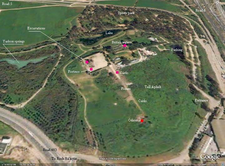
- Annotated Satellite Image
of Aphek from biblewalks.com
- Aphek in Google Earth
 Aphek
Aphek
click on image to explore this site on a new tab in Google Earth - Aphek on govmap.gov.il
 Aphek
Aphek
click on image to explore this site on a new tab in govmap.gov.il
- Plan of the site from
Stern et al (1993)
 Map of the mound, excavation areas, and general plan of the principal remains of Aphek
Stern et al (1993)
- Plan of the site from
Stern et al (1993)
Map of the mound, excavation areas, and general plan of the principal remains of Aphek
Stern et al (1993)
| Effect | Location | Image (s) | Comments |
|---|---|---|---|
| Tilted and distorted walls and subsiding arches | unspecified
Map of the mound, excavation areas, and general plan of the principal remains of Aphek Stern et al (1993) |
 Figure 6.
One of the subsided arches at Tel Afek (Antipatris) attributed to the 419 AD earthquake. Sagging of columns and arches occurs also in aseismically subsiding ground. In the present case, arch subsidence is accompanied by strongly tilted and distorted walls and joints. Karcz and Kafri (1978: 244-245) |
tilted and distorted walls and subsiding arches- Karcz and Kafri (1978: 244-245) |
- Earthquake Archeological Effects chart
of Rodríguez-Pascua et al (2013: 221-224)
 Earthquake Archeological Effects (EAE)
Rodríguez-Pascua et al (2013: 221-224)
| Effect | Location | Image(s) | Description | Intensity |
|---|---|---|---|---|
| Houses Destroyed (Collapsed Walls) | Antipatris |
|
VIII+ |
- Earthquake Archeological Effects chart
of Rodríguez-Pascua et al (2013: 221-224)
Earthquake Archeological Effects (EAE)
Rodríguez-Pascua et al (2013: 221-224)
| Effect | Location | Image (s) | Comments | Intensity |
|---|---|---|---|---|
| Tilted and distorted walls and subsiding arches | unspecified
Map of the mound, excavation areas, and general plan of the principal remains of Aphek Stern et al (1993) |
Figure 6. One of the subsided arches at Tel Afek (Antipatris) attributed to the 419 AD earthquake. Sagging of columns and arches occurs also in aseismically subsiding ground. In the present case, arch subsidence is accompanied by strongly tilted and distorted walls and joints. Karcz and Kafri (1978: 244-245) |
tilted and distorted walls and subsiding arches- Karcz and Kafri (1978: 244-245) |
VII + |