Yagur Shutter Ridges

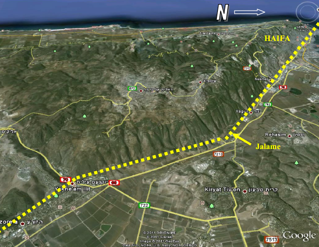 Fig. 11 (left)
Evidence for tectonic activity along the Yagur fault [aka Carmel Fault] during the late Pleistocene and the Holocene. The last 13 ka are marked in yellow.
Fig. 1 (right)
The trace of the Yagur fault [aka the Carmel Fault] between Yoqneam and the Mediterranean
all images from Zilberman et al. (2011)
Only one seismic event was detected in the Holocene on the Yagur Shutter Ridges. It was found in the southern shutter ridge but not the northern one. All other detected events were older. The Yagur Fault is also known as the Carmel fault.
 Fig. 2
The location of the two studied shutter ridges (marked by red ellipses). The main faults are marked by yellow dotted lines and the direction of the lateral displacement is marked by yellowish arrows.
Zilberman et al. (2011)
The North Shutter Ridge (NSR) is located in the outlet of a small second order stream, some 2.5 km north of the Southern Shutter Ridge (SSR) (Zilberman et al., 2006; Ashkar Halak, 2009). The blocking ridge is some 100 m long, built of a northward-tilted Turonian limestone sequence. The southern edge of the ridge was breached by the stream forming a V-shaped outlet with a shallow alluvial fan stretching to the north. The tributaries upstream of the blocked channels show a westward deflection from a straight northward flowing course as expected on the steep northern slopes of Mt. Carmel.
This deflected course is attributed to the left lateral displacement by the Yagur fault (Achmon, 1986, Gluck, 2002, Ashkar-Halak, 2009). The offset decreases from about 500 m in the eastern tributary, to about 150 m in the western tributary.
The shutter ridge is a part of a 300-400 m wide shear zone, characterized by shattered rocks and dense vertical fracture system (Fig. 2). It rises some 20 m above the alluvial plain that extends from its foot northward toward the Qishon River (fig. 3).
 Fig. 3
A southward view at Mt. Carmel showing the blocked and displaced fluvial system. The shear zone of the Yagur fault is marked by two black dotted lines. The outlet of the main channel is offset by ~500 m in relation to the confluence point of its southern tributaries. The shutter ridge reflects an additional offset of ~100 m.
Zilberman et al. (2011)

Figure 1
Location map. The Yagur and the Nesher faults are displayed on the 1:200.000 geological map by Sneh et al. 1998
Zilberman et al. (2008)
The Carmel fault runs along an ancient suture line that separate between two different geological provinces: The northern province, which includes northern Israel and Lebanon is characterized by a thin crust (about 23 km) while the southern province that includes the microplate of Israel and the Sinai peninsula (Salamon et al., 1996), has a thicker crust (more than 30 km) (Ginzburg and Folkman, 1980; Ben Avraham and Ginzburg,1990; Hofstteter et al, 1991).These two provinces differ in their structural character, seismic activity and style of topography (Achmon and Ben Avraham, 1997). This tectonic boundary is suggested to be a regional important structure since the Palaeozoic (Ben Avraham and Ginzburg, 1990), The Jurrasic (Derin, 1974), or Cretaceous (Kafri and Folkman, 1981).
The Carmel tectonic line shows a relatively high seismic activity (Ben Menhaem and Aboody, 1981; Shapira and Feldman, 1987, VanEck and Hofstteter, 1990), and is considered by De Sitter (1962), Freund, (1970), Garfunkel et al., (1981), and Hofstetter et al. (1996), among others, as a seismically active branch of the Dead Sea Transform (DST).
The origin and the age of the Carmel fault is a source of controversy. Some connected its origin to the Dead Sea Rift during the Middle Miocene and considered it as a left lateral strike slip that branches from the DST and transfers part of the sinistral movement to the Levant continental margin (De sitter, 1962, Fruend, 1970, Rotstein et al., 1993; Schattner et al., 2006). Others suggested that it predated the DST and was established during the opening of the Red Sea as part of the NW oriented "Erythrean" tectonic system (Picard, 1931; Picard and Kashai, 1958; Horowitz, 1979; Schattner, 2005).
The tectonic domain of the Carmel fault and its sense of displacement are also under debate. Ron (1984) and Ron and Eyal, (1985) concluded that the structure of the Galilee and the Carmel regions was developed under a Miocene stress field of E-W σHmax and Pliocene to recent N-S extensional stress field. A later work (Ron et al., 1990) explained the Carmel structure as a result of a uniform stress field where σHmax is in E-W direction.
Matmon et al., (2003) suggested that the structures of the Lower Galilee, Yizre'el Valley and the Carmel have developed since the Early Miocene under continuous extensional domain. This model is in contrast to the sinistral movement of some of 3-4 km, which was estimated for the Carmel fault by Arad (1965), Fruend, (1970), and Rotstein et al., (1993), of which about 300 m are considered by Achmon (1986) as a young motion, which displaces stream channels.
Sinistral offset of alluvial fans and streams was described by Achmon (1986) and Gluck (2001) from the northeastern mountain front of the Carmel. A left lateral component also characterizes some of the recent earthquake epicenters detected along the northwestern segment of the Carmel tectonic line (Hofstteter et al., 1996). The focal plane solution of the present seismic activity of the fault is therefore in accord with the model suggested by De-Sitter (1962), Fruend (1970) and Schattner (2006) to the entire fault system along the Carmel Line and the Carmel Block. However, relocation of earthquakes epicenters that occurred in this seismogenic zone since 1984 by Shamir, (2006), found a diffuse distribution of the epicenters, with the moderate activity taking place mostly north-east of the mapped fault line.
The Carmel fault crosses the down town of Haifa, and runs just south of the chemical industry area of the Haifa bay, and therefore is a potentially source of a seismic hazard for this highly populated region.
The aim of the present research was to study the young (Pleistocene-Holocene) paleotectonic activity in selected sites along the Carmel fault system by conducting a paleoseismic analysis.
Two tectonic elements were analyzed in the present stage
- The Nesher fault, which is a branch of the Carmel Fault
- The N-S oriented segment of the Carmel Fault running between Yoqneam and Jalame (Fig. 1).
Figure 1
Location map. The Yagur and the Nesher faults are displayed on the 1:200.000 geological map by Sneh et al. 1998
Zilberman et al. (2008)
- Fig. 1 Yagur Fault Trace
from Zilberman et al. (2011)
Fig. 1
The trace of the Yagur fault [aka the Carmel Fault] between Yoqneam and the Mediterranean
Zilberman et al. (2011) - Fig. 2 Yagur Shutter Ridges
from Zilberman et al. (2011)
Fig. 2
The location of the two studied shutter ridges (marked by red ellipses). The main faults are marked by yellow dotted lines and the direction of the lateral displacement is marked by yellowish arrows
Zilberman et al. (2011) - Fig. 3 Stream Displacement
on Yagur Shutter Ridges from Zilberman et al. (2011)
Fig. 3
A southward view at Mt. Carmel showing the blocked and displaced fluvial system. The shear zone of the Yagur fault is marked by two black dotted lines. The outlet of the main channel is offset by ~500 m in relation to the confluence point of its southern tributaries. The shutter ridge reflects an additional offset of ~100 m.
Zilberman et al. (2011) - Yagur Shutter Ridges
in Google Earth
 Yagur Shutter Ridges
click on image to explore this site on a new tab in Google Earth - Yagur Shutter Ridge
on govmap.gov.il
 Yagur Shutter Ridge (approx. location)
click on image to explore this site on a new tab in govmap.gov.il
Fig. 11
Evidence for tectonic activity along the Yagur fault during the late Pleistocene and the Holocene. The last 13 ka are marked in yellow.
Zilberman et al. (2011)

Fig. 11
Tectonic and morphologic elements in the study area
Zilberman et al. (2007)

Fig. 15
Columnar sections of the Back-Barrier Terrace (From Ashqar et al in prep.)
Zilberman et al. (2007)

Fig. 6
A westward view of the trench excavated across the flat terrace that accumulated between the shutter ridge and the slopes of Mt. Carmel.
Zilberman et al. (2011)

Fig. 7
The log of the trench excavated across the back-barrier terrace of the NSR.
Zilberman et al. (2011)

Fig. 8
A southward view at the trench. In the front – the white shutter ridge. Most of the fill is the reddish-brown unit 4, covered by dark brown younger colluvium. The white boulders (marked by the arrow) are part of the coarse facies of unit 4.
Zilberman et al. (2011)

Fig. 9
The coarse facies of unit 4. The size of the boulders (marked in yellow color) is up to 70 cm and they are mostly matrix supported.
Zilberman et al. (2011)

- Fig. 4 North Shutter Ridge
from Zilberman et al. (2011)
 Fig. 4
The North Shutter Ridge . The blocked stream is marked by a blue line. The outlet of the stream, which is incised in the southern margin of the ridge, is hidden by the vegetation.
Zilberman et al. (2011) - Fig. 5 Shattered rocks
from Zilberman et al. (2011)
 Fig. 5
Shattered rocks built of cemented breccia. The exposed surface is a north- facing fault plain of the Yagur fault shear zone.
Zilberman et al. (2011)
A shutter ridge is a barrier formed across a stream-valley by tectonic activity, which blocks the downstream flow (Burbank and Anderson, 2001). The barrier can be formed by vertical (normal or reverse) or lateral displacement. The blocked stream can change its course and flow around the barrier or it can fill the reservoir formed behind the tectonic dam by sediments that accumulate up to the top of the barrier and then overflow it.
Two sites in streams that were blocked by shutter ridges were found along the Carmel fault (Fig. 1), both located along the N-S oriented segment that extends between Yoqneam and Jalame (Achmon, 1986, 1991; Ashqar, 2006). This segment was considered by Achmon (1986) a restraining bend, associated with intensive deformation and block rotation. He estimated that the shutter ridges were formed due to young lateral offset of about 300 m.
The shutter ridge selected for the present study is located at an outlet of a small stream, about two km long (coords. 20950/23205). It separates between the upper reach of the stream channel that incised in the steep northeast-facing slopes of the Carmel and its alluvial fan, which was deposited north of the slope margins (Fig. 11).
Fig. 11
Tectonic and morphologic elements in the study area
Zilberman et al. (2007)
Fig. 11
Tectonic and morphologic elements in the study area
Zilberman et al. (2007)
The northeastern slope of the Carmel Mt. is composed in the study area of a NE tilted Turonian sequence. This sequence builds unstable slopes with abundant landslides, and in fact it is difficult to find a slope that was not disturbed by some kind of mass-movement.
The Carmel fault crosses the eastern margins of the Carmel, forming a shear zone several hundreds meters wide (Achmon, 1986). The Shutter ridge is composed of eastward tilted bedded limestone, which forms a narrow ridge that extends several hundreds meters to the south of the stream (Fig. 11). A flat alluvial terrace covered by colluvium and soils, developed along the western backside of the ridge (Fig. 12). In the west this terrace is bounded by a fault that runs along the Carmel slope (Fig. 13). Additional faults occur further to the west on the steep slopes.
A large morphological cirque was formed by landslide scar between altitude 200 and 300m in the upper stream valley (Fig. 11). This landslide blocked the stream channel and formed a series of knick points expressed as dry waterfalls. This barrier also prevented alluvial materials from reaching the down stream channel and therefore enhanced an incision regime near the stream outlet.

 Fig. 12 (left)
The back-barrier terrace south of the stream valley
Fig. 13 (right)
The fault plane that forms the western boundary of the Back Barrier Terrace
both from Zilberman et al. (2007)
Fig. 11
Evidence for tectonic activity along the Yagur fault during the late Pleistocene and the Holocene. The last 13 ka are marked in yellow.
Zilberman et al. (2011)
Several studies suggesting Pleistocene and Holocene tectonic activity along the Yagur fault have been published in the last years (Fig. 11).
- A vertical displacement of about ten meters was detected in the subsurface trace of the Yagur fault near Nesher. The displaced units are about 50 ky old (Salamon, 2000).
- A small displacement of a 30 ka alluvial unit was described by Gluck (2002) in a small alluvial fan that covers the Yagur fault trace near Kibbutz Yagur.
- Several episodes of destruction, some of them are assumed to have been induced by earthquakes, were described from Megido ruins by Marco et al., (2006). It was suggested (although with no clear evidence) that some of these seismic events originated at the Yagur fault.
- A study of clusters of broken speleothems in Denya Cave, located only 4 km from the Yagur fault (Braun, 2009), suggest that each of them is related to a strong ground acceleration induced by a seismic event. Two of these clusters were dated to the Holocene circa 10ka and 5ka.