Rehovot ba Negev
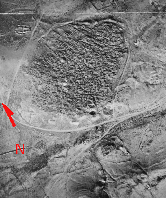 III.6.
Aerial photograph after the fourth season (courtesy J. Shershevski)
Approx. North Arrow (in red) added by JW
Tsafrir (1988)
| Transliterated Name | Source | Name |
|---|---|---|
| Rehovot ba Negev | Hebrew | רחובות בנגב |
| Khirbet Ruheibeh | Arabic | كهيربيت روهييبيه |
| Rehoboth | Biblical Hebrew | רְחוֹבוֹת |
| Berteiba | Greek | Βηρθειβα |
| Beer Tiv or Beer Tova | ||
| Bethomolchon | Greek | βετομολαχον |
| Beth Malchu |
- Fig. 1- Location Map
from Korzhenkov and Mazor (2014)
 Fig. 1
The ancient caravan routes (thick lines) in the Negev desert, the intensities of the seismic oscillations (according to MSK-64 scale) of past earthquakes in the old cities studied by the authors are shown (scale 1 : 1 500 000)
Korzhenkov and Mazor (2014) - Fig. 1 - Location Map from
Tsafrir et al (1988)
 Fig. 1
Location Map
Tsafrir et al (1988) - Rehovot ba Negev in Google Earth
 Rehovot ba Negev
click on image to explore this site on a new tab in Google Earth - Rehovot ba Negev on govmap.gov.il
 Rehovot ba Negev on govmap.gov.il
click on image to explore this site on a new tab in govmap.gov.il
- Fig. 4 - Musil's ground plan
of the site from Tsafrir et al (1988)
 Fig. 4
Musil's ground plan of the site
Tsafrir et al (1988) - Fig. 6 - Lawrence and Woolley's
ground plan of the site from Tsafrir et al (1988)
 Fig. 6
Lawrence and Woolley's ground plan of the site.
Tsafrir et al (1988)
- Fig. 4 - Musil's ground plan
of the site from Tsafrir et al (1988)
Fig. 4
Musil's ground plan of the site
Tsafrir et al (1988) - Fig. 6 - Lawrence and Woolley's
ground plan of the site from Tsafrir et al (1988)
Fig. 6
Lawrence and Woolley's ground plan of the site.
Tsafrir et al (1988)
- Fig. 3 - Plan of the
Northern Church from Korzhenkov and Mazor (2014)
 Fig. 3
Plan of the Northern Church (north arrow added by JW)
Korzhenkov and Mazor (2014) - Fig. 7 - Plan of the
Northern Church from Tsafrir et al (1988)
 Fig. 7
A ground plan of the northern church
Giora Solar
Tsafrir et al (1988) - Fig. 11 - Plan of the
Northern Church with wall numbers and loci from Tsafrir et al (1988)

Fig. 11
A schematic plan of walls and loci
- 500 — The southern apse and the part of the chancel in front of it
- 501 — The central apse
- 502 — The bema in front of the central apse
- 503 — The southern staircase to the crypt
- 504 — The northern staircase to the crypt
- 505 — The room behind the southern apse
- 506 — A section in the central apse down to bedrock
- 507 — The northern apse and the part of the chancel in front of it
- 508 — The crypt
- 509 — A side room flanking the southern aisle
- 510 — The room behind the northern apse
- 511 — Canceled
- 512 — The eastern (main) part of the northern chapel
- 513 — The northern aisle
- 514 — The nave
- 515 — The southern aisle
- 516 — The area outside the southern gate of the atrium
- 517 — The staircase tower
- 518 — The southern part of the eastern wing of the atrium
- 519 — The southern gate of the atrium and the area in front of it
- 520 — A tomb in the northern aisle
- 521 — The western part of the northern chapel
- 522 — The northern part of the eastern wing of the atrium
- 523 — The southeastern corner of the inner court of the atrium
- 524 — The cistern in the atrium and the objects that were piled outside of it when it was previously cleaned
- 525 — The central part of the eastern wing of the atrium
- 531 — A tomb in the southern aisle
- 538 — A tomb in the southern aisle
- 539 — A tomb in the southern aisle
Tsafrir et al (1988) - Fig. 10 - isometric
reconstruction of the Northern Church from Tsafrir et al (1988)
 Fig. 10
An isometric reconstruction of the northern church
Tsafrir et al (1988) - Fig. 9 - isometric
reconstruction of remains found in situ of the northern church from Tsafrir et al (1988)
 Fig. 9
An isometric reconstruction of remains found in situ in the northern church including the south wing of the atrium
Tsafrir et al (1988) - Fig. 18 - isometric
reconstruction of the crypt below the pavement of the Northern Church from Tsafrir et al (1988)
 Fig. 18
An isometric reconstruction of the crypt below the pavement of the church
Tsafrir et al (1988)
- Fig. 7 - Plan of the
Northern Church from Tsafrir et al (1988)
Fig. 7
A ground plan of the northern church
Giora Solar
Tsafrir et al (1988) - Fig. 11 - Plan of the
Northern Church with wall numbers and loci from Tsafrir et al (1988)
Fig. 11
A schematic plan of walls and loci
- 500 — The southern apse and the part of the chancel in front of it
- 501 — The central apse
- 502 — The bema in front of the central apse
- 503 — The southern staircase to the crypt
- 504 — The northern staircase to the crypt
- 505 — The room behind the southern apse
- 506 — A section in the central apse down to bedrock
- 507 — The northern apse and the part of the chancel in front of it
- 508 — The crypt
- 509 — A side room flanking the southern aisle
- 510 — The room behind the northern apse
- 511 — Canceled
- 512 — The eastern (main) part of the northern chapel
- 513 — The northern aisle
- 514 — The nave
- 515 — The southern aisle
- 516 — The area outside the southern gate of the atrium
- 517 — The staircase tower
- 518 — The southern part of the eastern wing of the atrium
- 519 — The southern gate of the atrium and the area in front of it
- 520 — A tomb in the northern aisle
- 521 — The western part of the northern chapel
- 522 — The northern part of the eastern wing of the atrium
- 523 — The southeastern corner of the inner court of the atrium
- 524 — The cistern in the atrium and the objects that were piled outside of it when it was previously cleaned
- 525 — The central part of the eastern wing of the atrium
- 531 — A tomb in the southern aisle
- 538 — A tomb in the southern aisle
- 539 — A tomb in the southern aisle
Tsafrir et al (1988) - Fig. 10 - isometric
reconstruction of the Northern Church from Tsafrir et al (1988)
Fig. 10
An isometric reconstruction of the northern church
Tsafrir et al (1988) - Fig. 9 - isometric
reconstruction of remains found in situ of the northern church from Tsafrir et al (1988)
Fig. 9
An isometric reconstruction of remains found in situ in the northern church including the south wing of the atrium
Tsafrir et al (1988)
- Fig. 5 - Musil's ground plan
and sections of the bath-house from Tsafrir et al (1988)
 Fig. 5
Musil's ground plan of the bath house
- sections A-B above left
- C-D above right
- E-F below
Tsafrir et al (1988)
- Fig. 5 - Musil's ground plan
and sections of the bath-house from Tsafrir et al (1988)
Fig. 5
Musil's ground plan of the bath house
- sections A-B above left
- C-D above right
- E-F below
Tsafrir et al (1988)
- Fig. 2 - Plan of Area B
from Tsafrir et al (1988)
 Fig. 2
A ground plan for Area B
Tsafrir et al (1988) - Fig. 1 - Plan of Area B
from Tsafrir and Holum (1988)
 Fig. 1
Plan of Area B
Tsafrir and Holum (1988)
- Fig. 2 - Plan of Area B
from Tsafrir et al (1988)
Fig. 2
A ground plan for Area B
Tsafrir et al (1988) - Fig. 1 - Plan of Area B
from Tsafrir and Holum (1988)
Fig. 1
Plan of Area B
Tsafrir and Holum (1988)
- Fig. 3 - Plan of Area C
(stable buildings) from Tsafrir and Holum (1988)
 Fig. 3
Plan of Area C; the stable buildings
Tsafrir and Holum (1988) - Fig. 3 - Plan of Area C
from Tsafrir et al (1988)
 Fig. 3
A ground plan of the Khan, Area C
Tsafrir et al (1988)
- Fig. 3 - Plan of Area C
(stable buildings) from Tsafrir and Holum (1988)
Fig. 3
Plan of Area C; the stable buildings
Tsafrir and Holum (1988) - Fig. 3 - Plan of Area C
from Tsafrir et al (1988)
Fig. 3
A ground plan of the Khan, Area C
Tsafrir et al (1988)
- Fig. 4 - Plan of the
central church in a later phase in Area D from Tsafrir and Holum (1988)
 Fig. 4
Area D; the central church, later phase
Tsafrir and Holum (1988)
- Fig. 4 - Plan of the
central church in a later phase in Area D from Tsafrir and Holum (1988)
Fig. 4
Area D; the central church, later phase
Tsafrir and Holum (1988)
- Fig. 8 - Section along
the northern church staircase from Tsafrir et al (1988)
 Fig. 8
A section along the northern church staircase, including elevations of the northern wall of the crypt and the synthronon
Tsafrir et al (1988) - Fig. 12 - Section L.506
in the apse (northern edge) from Tsafrir et al (1988)
 Fig. 12
The northern edge of the section L.506 in the apse
Tsafrir et al (1988) - Fig. 13 - Section L.506
in the apse (southern edge) from Tsafrir et al (1988)
 Fig. 13
The southern edge of the section L.506 in the apse
Tsafrir et al (1988) - Fig. 20 - eastern wall
of the crypt and the cavity for reliquary as found from Tsafrir et al (1988)
 Fig. 20
The eastern wall of the crypt and the cavity for reliquary as found
Tsafrir et al (1988) - Fig. 21 - southern entrance
into the crypt from Tsafrir et al (1988)
 Fig. 21
The southern entrance into the crypt (L. 503), showing the walls of the corridor, the arch of the southern door and the level of the bema above, looking north.
Tsafrir et al (1988) - Fig. 22 - A section of
the accumulation of debris in the northern entrance into the crypt from Tsafrir et al (1988)
 Fig. 22
A section of the accumulation of debris in the northern entrance into the crypt (L. 504).
Tsafrir et al (1988) - Fig. 23 - upper part of
the northern entrance into the crypt, the bema, the apse and the rear room from Tsafrir et al (1988)
 Fig. 23
An elevation of the upper part of the northern entrance into the crypt, the bema, the apse and the rear room L. 505, looking south.
Tsafrir et al (1988) - Fig. 19 - Reconstructed
section of the church and the crypt from Tsafrir et al (1988)
 Fig. 19
Reconstructed section of the church and the crypt
Tsafrir et al (1988)
- Fig. 8 - Section along
the northern church staircase from Tsafrir et al (1988)
Fig. 8
A section along the northern church staircase, including elevations of the northern wall of the crypt and the synthronon
Tsafrir et al (1988) - Fig. 12 - Section L.506
in the apse (northern edge) from Tsafrir et al (1988)
Fig. 12
The northern edge of the section L.506 in the apse
Tsafrir et al (1988) - Fig. 13 - Section L.506
in the apse (southern edge) from Tsafrir et al (1988)
Fig. 13
The southern edge of the section L.506 in the apse
Tsafrir et al (1988)
- Plate III.30 - Aerial
View of the northern church from Tsafrir et al (1988)
 Plate III.30
Aerial View of the northern church, looking southeast
Tsafrir et al (1988) - Plate III.31 - Aerial
View of the northern church from Tsafrir et al (1988)
 Plate III.31
Aerial View of the church, looking southwest
Tsafrir et al (1988) - Plate III.32 - General
View of the northern church from the outside from Tsafrir et al (1988)
 Plate III.32
General view of the church from the outside, looking northwest
Tsafrir et al (1988) - Plate III.33 - The church
in process of excavation from Tsafrir et al (1988)
 Plate III.33
The church in process of excavation, looking northeast
Tsafrir et al (1988) - Plate III.34 - General
view of the church from Tsafrir et al (1988)
 Plate III.34
General view of the church, looking southeast
Tsafrir et al (1988)
- Fig. 10 - Fallen Arches
and Roofing slabs in room L.206 from Tsafrir et al (1988)
 Plate III.14
Fallen Arches and Roofing slabs in room L.206, looking south
Tsafrir et al (1988) - Plate III.38 - Bases
and drums found near the southern apse from Tsafrir et al (1988)
 Plate III.38
Bases and drums found near the southern apse, looking southeast.
Tsafrir et al (1988) - Plate III.39 - Bases,
drums, and capitals near the northern entrance to the crypt from Tsafrir et al (1988)
 Plate III.39
Bases, drums, and capitals near the northern entrance to the crypt, looking southeast.
Tsafrir et al (1988) - Plate III.41 - column base
and two voussoirs of the fallen arcade; the northern colonnade from Tsafrir et al (1988)
 Plate III.41
A column base and two voussoirs of the fallen arcade; the northern colonnade, looking south.
Tsafrir et al (1988) - Plate III.54 - Displaced
(sheared) northern end of the partition wall W.31 between the bema and the apse from Tsafrir et al (1988)
 Plate III.54
The northern end of the partition wall between the bema (left) and the apse (W. 31). Note the raised step and the bulk of hardened chalk that enable the reconstruction of a three-stepped synthronon, looking northeast.
JW: Note displaced wall (sheared)
Tsafrir et al (1988) - Plate III.57 - The southern
apse (L. 500) from Tsafrir et al (1988)
 Plate III.57
The southern apse (L. 500), looking east.
Tsafrir et al (1988) - Fig. 22 - A section of
the accumulation of debris in the northern entrance into the crypt from Tsafrir et al (1988)
Fig. 22
A section of the accumulation of debris in the northern entrance into the crypt (L. 504).
Tsafrir et al (1988) - Plate III.80 - Accumulation
of architectural parts in the crypt from Tsafrir et al (1988)
 Plate III.80
Accumulation of architectural parts in the crypt
Tsafrir et al (1988) - Plate III.81 - chancel
post and screen of the bema which fell into the N entrance to the crypt from Tsafrir et al (1988)
 Plate III.81
Parts of a chancel post and a chancel screen of the bema, which fell from the northern entrance into the crypt (L. 504).
Tsafrir et al (1988) - Plate III.87 - Roofing
slabs in room L.505 from Tsafrir et al (1988)
 Plate III.87
Roofing slabs in room L.505, looking northwest.
Tsafrir et al (1988) - Plate III.104 - window
in the northeastern corner of the staircase in the staircase tower (L.517) from Tsafrir et al (1988)
 Plate III.104
A window in the northeastern corner of the staircase [in the staircase tower (L.517)], looking north from the tower outside.
Tsafrir et al (1988) - Plate III.111 - secondary
wall built upon the stylobate of the atrium from Tsafrir et al (1988)
 Plate III.111
A secondary wall built upon the stylobate of the atrium (see stylobate and column base in left part of photograph), looking west.
Tsafrir et al (1988) - Plate III.112 - secondary
wall built upon the stylobate of the atrium from Tsafrir et al (1988)
 Plate III.112
The secondary wall built upon the stylobate of the atrium, looking north.
Tsafrir et al (1988) - Plate III.119 - Voussoirs
and roofing slabs in the debris of the chapel from Tsafrir et al (1988)
 Plate III.119
Voussoirs and roofing slabs in the debris of the chapel, looking southwest
Tsafrir et al (1988) - Plate 21.B - fallen
roofing arches in L.306 of Area C (the Khan) from Tsafrir & Holum (1988)
 Plate 21.B
Area C: central room of stable, L.306, looking south. Note fallen roofing arches
Tsafrir & Holum (1988)
- Fig. 18 - Water Reservoir
at Rehovot ba Negev from Korzhenkov and Mazor (2014)
 Fig. 18
Rehovot-ba-Negev, seismogenic (?) rupture at the SE wall of the water reservoir. The reservoir was partly cut out of the bedrock and is partly brick-built. Also note the collapse of a significant part of the armored layer which partly covered the reservoir from SW
Korzhenkov and Mazor (2014) - Fig. 4 - Water Reservoir
at Rehovot ba Negev from Rubin (1988)
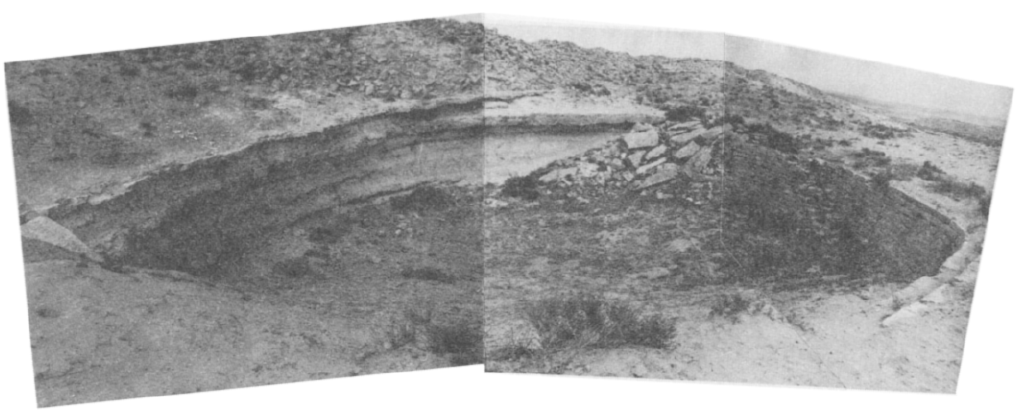 Fig. 4
Rehovot: a panoramic view of the reservoir
Rubin (1988)
- Fig. 5 - Musil's ground plan
and sections of the bath-house from Tsafrir et al (1988)
Fig. 5
Musil's ground plan of the bath house
- sections A-B above left
- C-D above right
- E-F below
Tsafrir et al (1988) - Fig. 5 - Musil's ground plan
and sections of the bath-house from Tsafrir et al (1988) (magnified)
Fig. 5
Musil's ground plan of the bath house
- sections A-B above left
- C-D above right
- E-F below
Tsafrir et al (1988) - Plate III.28 - The rebuilt
Byzantine bath-house from Tsafrir et al (1988)
 III.28
The Byzantine bath house as photographed by Musil
Tsafrir et al (1988) - Fig. 10 - Destroyed British
well-house from Korzhenkov and Mazor (2014)
 Fig. 10
Destroyed well-house, built under the British Mandate, above the ruins of the Byzantine bath house
Korzhenkov and Mazor (2014) - Plate III.9 - The British
well-house from Tsafrir et al (1988)
 III.9
III.9
The well-house, built under the British Mandate, above the ruins of the Byzantine bath house
Tsafrir et al (1988)
Korzhenkov and Mazor (2014) report that Tsafrir et al (1988) date destruction of a rebuilt Byzantine bath house (Plate III.28) to Turkish (i.e. Ottoman) times but I can't find any reference to dating or destruction of the rebuilt Byzantine bath house in Tsafrir et al (1988). It is only mentioned as having been examined in previous studies of the site. Korzhenkov and Mazor (2014) report to have
have traced the impact of an earthquake at Turkish-British constructionsin the Bedouin village of Khalasa built on or adjacent to ruins of ancient Haluza, noting that
the deformations cover a large areaand suggest that
the earthquake which affected the Khalasa village would have also left traces in buildings of the same age at Rehovot-ba-Negev. Korzhenkov and Mazor (2014) note that the well-house built during the British mandate was also significantly destroyed.
| Seismic Effect | Location | Figure(s) | Comments |
|---|---|---|---|
| Tilted wall | Southern Wall of Northern Church - Station 10
Fig. 3 Plan of the Northern Church (north arrow added by JW) Korzhenkov and Mazor (2014) |
 Fig. 7
A northward tilt of the original southern wall (field station 10). Note the open space between the mentioned wall and the perpendicular adjacent wall of a small room and the shifting of the upper part of the preserved revetment wall, also northward Korzhenkov and Mazor (2014) |
|
| Tilted wall | Northern Wall of Northern Church - Station 12
Fig. 3 Plan of the Northern Church (north arrow added by JW) Korzhenkov and Mazor (2014) |
 Fig. 8
A southward tilt of the whole wall of the Northern Church
The angle of tilt is increasing up along the wall (a "skyscraper" effect) Korzhenkov and Mazor (2014) |
The whole northern wall of the Church (field station 12 in fig. 3) has a significant tilt to the south (figs. 8 a. b)- Korzhenkov and Mazor (2014) |
| Displaced walls | Southern Wall of Northern Church - Station 10
Fig. 3 Plan of the Northern Church (north arrow added by JW) Korzhenkov and Mazor (2014) |
 Fig. 12
Rehovot-ba-Negev, northward tilting and shifting of the southern wall of the Northern Church Korzhenkov and Mazor (2014) |
there is also shifting (10–15 cm) of the upper row of the stones [of the southern wall of the northern church] in the same direction [northward] (fig. 12).- Korzhenkov and Mazor (2014) |
| Deformed wall supported by a revetment wall | Northern Wall of of the big courtyard (i.e. the atrium) of the Northern Church - Station 6
Fig. 3 Plan of the Northern Church (north arrow added by JW) Korzhenkov and Mazor (2014) |
 Fig. 19
A deformed northern wall is supported by a revetment wall (field station 6). A strong deformation of the original wall is seen by wide openings between stones and a tilted block at the central part of the Figure Korzhenkov and Mazor (2014) |
Sloping support walls have been found in the North and South Churches and in private buildings. The core of the revetment is a combination of small rough stones and earth, with a layer of larger roughly-dressed stones on the outside. The revetment is cemented by grey mortar, consisting of chalk and ashes. The revetment wall is laid on the virgin loess. The wall reaches 1.80 m in height and is 90 cm wide at the base. The whole northern wall of the big courtyard (field station 6 in fig. 3) of the North Church is surrounded by the revetment wall (fig. 19), its half was demolished at present time.- Korzhenkov and Mazor (2014) |
| Deformed wall supported by a revetment wall | Northern Wall of Northern Church - Station 7
Fig. 3 Plan of the Northern Church (north arrow added by JW) Korzhenkov and Mazor (2014) |
 Fig. 20
Continuation of the revetment wall (field station 7) Korzhenkov and Mazor (2014) |
The revetment wall continues around the northern room (field station 7 in fig. 3) of the main premises of the North Church (fig. 20)- Korzhenkov and Mazor (2014) |
| revetment walls | NE corner of the Northern Church - Station 8
Fig. 3 Plan of the Northern Church (north arrow added by JW) Korzhenkov and Mazor (2014) |
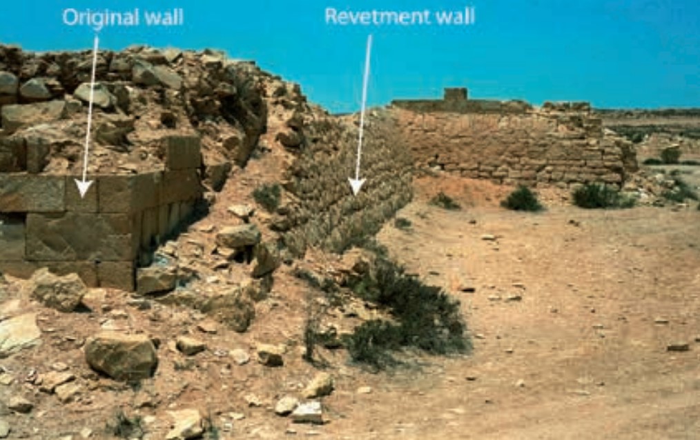 Fig. 21
Revetment wall at the NE corner Korzhenkov and Mazor (2014) |
At the NE corner of the North Church, one can observe the continuation of an encircling revetment wall (field station 8 in fig. 3). At this corner the wall is destroyed (fig. 21), with the stones collapsing northwards on an original wall. The encircling revetment wall is of good quality. The destruction event (an earthquake), which deformed the original wall, occurred before the decline of the Byzantine Empire. There was then another seismic event which led to the destruction of the revetment wall itself. The last event was probably an end of ›civilized‹ life here.- Korzhenkov and Mazor (2014) |
| Columns supported by walls | Northern Church - possibly in the Atrium
Fig. 7 A ground plan of the northern church Giora Solar Tsafrir et al (1988)
A schematic plan of walls and loci
Tsafrir et al (1988)
Fig. 10An isometric reconstruction of the northern church Tsafrir et al (1988)
Fig. 9An isometric reconstruction of remains found in situ in the northern church including the south wing of the atrium Tsafrir et al (1988) |
 Fig. 22
Rehovot-ba-Negev, Northern Church. An ancient column within a wall that was built in order to protect it from possible future destruction Korzhenkov and Mazor (2014) |
Columns at ancient and modern buildings cause the redistribution of the static load of the whole building construction, and serve as art decoration of the internal and external parts of the building. When a researcher finds a column supported by a later wall, he can be sure that the column was severely deformed, making the supporting wall necessary. Such an example can be found in the North Church (fig. 22).- Korzhenkov and Mazor (2014) |
| Deformation of arches and roofs | Room L.207 in Area B
Fig. 2 A ground plan for Area B Tsafrir et al (1988)
Fig. 1Plan of Area B Tsafrir and Holum (1988) |
 Fig. 11
Collapse of the arch in room L.207, which has been filled with earth before its complete collapse Korzhenkov and Mazor (2014) |
the walls were not completely destroyed during the first shock that occurred in Late Roman times. The arches and roofs probably withstood the shock too, though many of them were significantly damaged (fig. 11). This is probably the reason why ancient people filled some of the rooms with earth in order to protect them from complete collapse.- Korzhenkov and Mazor (2014) |
| Features of later repair and rebuilding | ? in the Northern Church Window in NE corner of Staircase Tower (L.517) in the Northern Church
Fig. 7A ground plan of the northern church Giora Solar Tsafrir et al (1988)
A schematic plan of walls and loci
Tsafrir et al (1988)
Fig. 10An isometric reconstruction of the northern church Tsafrir et al (1988)
Fig. 9An isometric reconstruction of remains found in situ in the northern church including the south wing of the atrium Tsafrir et al (1988) |
Plate III.104 A window in the northeastern corner of the staircase [in the staircase tower (L.517)], looking north from the tower outside. Tsafrir et al (1988) |
Tsafrir et al. (1998:210) wrote that when the revetment wall was built around the church it closed the entrance to one room. A new threshold was installed which was about 60 cm above the former floor level. No remains of steps inside the room were found. This means that after the first earthquake the floor was covered by debris, which was not cleaned, but leveled, requiring a new threshold.- Korzhenkov and Mazor (2014) |
| Secondary use of building elements | Room L522 in the Northern Church Rooms L.512 and L.521 in the Chapel of the Northern Church
A schematic plan of walls and loci
Tsafrir et al (1988) |
Secondary use of stones from damaged and destroyed walls is a common feature at the cities that experienced strong earthquakes. For example, a large fragment of a water basin was found in an Early Arab secondary wall at the east end of the porch (Room L 522). Another secondary wall was discovered at the eastern porch of the atrium behind the stylobate and preserved it at a height of two-three rows, which blocked the atrium from the west.- Korzhenkov and Mazor (2014) |
| Seismic Effect | Location | Figures | Comments |
|---|---|---|---|
| Tilted Wall | Southern wall at the SE premises of the Northern Church - Station 3
Fig. 3 Plan of the Northern Church (north arrow added by JW) Korzhenkov and Mazor (2014) |
 Fig. 4
A tilt southward of the southern wall at the SE premises of the Northern Church (field station 3). The degree of the tilting is increasing with the distance from the abutted perpendicular wall. This phenomenon is the result of maximum freedom of oscillation at the central part of the wall Korzhenkov and Mazor (2014) |
the southern wall of the SE premises of the North Church (field station 3 in fig. 3) tilted southwards (fig. 4). The wall trend is 108º; declination azimuth is 198º; and the angle is up to 75º.- Korzhenkov and Mazor (2014) |
| tilted and collapsed (?) wall | Western wall at the SW end of the western yard of the Northern Church - Stations 3 & 4
Fig. 3 Plan of the Northern Church (north arrow added by JW) Korzhenkov and Mazor (2014) |
 Fig. 5
An 18º-tilt and a collapse of the western wall westward at the SW corner of the western yard (field station 4). Opening between two perpendicular walls is shown by a double arrow, and a through-going fissure (joint) cuts three adjacent stones in succession (shown by three white arrows) Korzhenkov and Mazor (2014) |
Another example can be seen at the same premises (field station 3) where one can observe the same damage pattern in the western wall: the wall trend is 13º, tilted to 81º and collapsed westward – toward azimuth 283º. Only a few fragments are preserved of the western wall, and only one stone high. The [western] wall continues northward. Here it has a tilt and a westward collapse analogous to the SW corner of the western yard in the North Church (field station 4 in fig. 3). The trend of the azimuth of the wall is 18º; it is tilted at an angle up to 72º; and the declination azimuth is 287º; this is also the direction of the wall collapse (fig. 5).- Korzhenkov and Mazor (2014) |
| Tilted Wall | Western wall of the Northern Church - Station 5
Fig. 3 Plan of the Northern Church (north arrow added by JW) Korzhenkov and Mazor (2014) |
 Fig. 6
Tilt of the western wall toward WNW at field station 5. There is an opening between the tilted wall and the perpendicular one Korzhenkov and Mazor (2014) |
|
| Tilted Wall | Southern wall of the Northern Church - Station 10
Fig. 3 Plan of the Northern Church (north arrow added by JW) Korzhenkov and Mazor (2014) |
Fig. 7 A northward tilt of the original southern wall (field station 10). Note the open space between the mentioned wall and the perpendicular adjacent wall of a small room and the shifting of the upper part of the preserved revetment wall, also northward Korzhenkov and Mazor (2014) |
The southern wall of the North Church (field station 10 in fig. 3) is tilted northward (fig. 7).The trend of the wall is 202º, and the maximum tilt angle is 77º. Because of this tilt one can observe an open space between the southern wall and the adjacent perpendicular one. The existence of revetment walls, supporting the southern wall of the Church from the south, indicates that the southern wall’s tilt occurred during the first of the Late Roman earthquakes. It seems that the southern wall began to tilt northward inside the building during the Early Arab earthquakes; additional evidence for this is the shift northwards of the upper part of the revetment wall. Stones of the perpendicular eastern wall are cracked in the small room marked on the plan. Nevertheless, this wall is better preserved (it is much higher) than the main southern wall of the North Church. This indicates that the seismic shocks during both earthquakes acted perpendicular to the main Church wall: it had freedom of oscillation and was significantly destroyed.- Korzhenkov and Mazor (2014) |
| Displaced Masonry Blocks | upper part of an arch column in one of the excavated quarters |
 Fig. 13
A horizontal 15 cm shift eastward of the upper part of an arch column in one of the excavated quarters Korzhenkov and Mazor (2014) |
a 15 cm shift eastward of two stones in the upper part of an arch column (fig. 13) in one of the excavated quarters of the ancient city. The arch above collapsed during the Byzantine shocks.- Korzhenkov and Mazor (2014) |
| Displaced Masonry Blocks - Rotated Stone | Eastern wall of the Northern Church - Station 9
Fig. 3 Plan of the Northern Church (north arrow added by JW) Korzhenkov and Mazor (2014) |
 Fig. 16
Clockwise rotation of a stone in an eastern wall (field station 9) Korzhenkov and Mazor (2014) |
The rotation of wall fragments around a vertical axis is a common phenomenon during strong earthquakes. Foundation stones are pulled out and rotated, indicating dynamic beating in the process of sharp horizontal oscillations of the whole wall (and not only its upper part). A seismic ground motion is the only mechanism that can cause rotation of building elements. A large number of observed rotations, and the obvious directional systematics, support this conclusion. An example of rotation (fig. 16) can be observed outside the eastern wall of the North Church (field station 9 in fig. 3). Here one stone in the upper preserved row was rotated clockwise. The general trend of the wall is 24º; and the trend of the rotated block is 26º.- Korzhenkov and Mazor (2014) |
| Displaced Masonry Blocks - Pushing of a wall by an adjacent perpendicular wall | Area C (The Khan)
Fig. 3 Plan of Area C; the stable buildings Tsafrir and Holum (1988) |
 Fig. 14
Deformation of two perpendicular walls at the Caravansary, the "feeding" wall pushed the perpendicular one. The later wall is significantly tilted. The "feeding" wall is also deformed: there are some openings in its upper part and joints (shown by arrows) crossing two stones are in the wall’s lower part Korzhenkov and Mazor (2014) |
The pushing of walls by a connected perpendicular wall has been identified as one of the seismic damage patterns at Mamshit – one of the ancient towns of the Negev desert, east of Rehovot-ba-Negev. ... A similar picture can be observed at the stables of the Caravansary (fig. 14). Here the ›feeding‹ wall pushed a perpendicular one. Both walls are significantly deformed, tilted (declination angle 22º) and crossed by joints.- Korzhenkov and Mazor (2014) |
| Displaced Masonry Blocks - Opening between two adjacent perpendicular walls | Western wall of the Northern Church - Station 4
Fig. 3 Plan of the Northern Church (north arrow added by JW) Korzhenkov and Mazor (2014) |
Fig. 5 An 18º-tilt and a collapse of the western wall westward at the SW corner of the western yard (field station 4). Opening between two perpendicular walls is shown by a double arrow, and a through-going fissure (joint) cuts three adjacent stones in succession (shown by three white arrows) Korzhenkov and Mazor (2014) |
|
| Tilted Wall - Opening between two adjacent perpendicular walls | Western wall of the Northern Church - Station 5
Fig. 3 Plan of the Northern Church (north arrow added by JW) Korzhenkov and Mazor (2014) |
Fig. 6 Tilt of the western wall toward WNW at field station 5. There is an opening between the tilted wall and the perpendicular one Korzhenkov and Mazor (2014) |
|
| Tilted Wall - Opening between two adjacent perpendicular walls | Western wall of the Northern Church - Station 3
Fig. 3 Plan of the Northern Church (north arrow added by JW) Korzhenkov and Mazor (2014) |
 Fig. 15
Opening between two adjacent perpendicular walls at the SE premises (field station 3) Korzhenkov and Mazor (2014) |
The pushing of a wall by an adjacent perpendicular one is quite common. The pushed wall is usually tilted or/and collapsed. Between this tilted wall and the perpendicular one (the pusher) an open space is often formed. This could also be due to the especial vulnerability of corners to large seismic shocks, because wave-parallel and wave-orthogonal walls oscillate at different amplitudes and frequencies. Ordinary old buildings often lack coupling elements between adjacent walls, and long-lasting strong seismic oscillation often causes gaps (or long open cracks) which may lead to the failure of corners.- Korzhenkov and Mazor (2014) |
| Penetrative fractures in masonry blocks - through-going joints | Western wall of the Northern Church - Station 4
Fig. 3 Plan of the Northern Church (north arrow added by JW) Korzhenkov and Mazor (2014) |
Fig. 5 An 18º-tilt and a collapse of the western wall westward at the SW corner of the western yard (field station 4). Opening between two perpendicular walls is shown by a double arrow, and a through-going fissure (joint) cuts three adjacent stones in succession (shown by three white arrows) Korzhenkov and Mazor (2014) |
|
| Penetrative fractures in masonry blocks - through-going joints | Area C (The Khan)
Fig. 3 Plan of Area C; the stable buildings Tsafrir and Holum (1988) |
Fig. 14 Deformation of two perpendicular walls at the Caravansary, the "feeding" wall pushed the perpendicular one. The later wall is significantly tilted. The "feeding" wall is also deformed: there are some openings in its upper part and joints (shown by arrows) crossing two stones are in the wall’s lower part Korzhenkov and Mazor (2014) |
there are some openings in its upper part and joints (shown by arrows) crossing two stones are in the wall’s lower part- Korzhenkov and Mazor (2014) |
| Penetrative fractures in masonry blocks - through-going joints | Wall to the right of the southern entrance into the Northern Church - Station 1
Fig. 3 Plan of the Northern Church (north arrow added by JW) Korzhenkov and Mazor (2014) |
 Fig. 17
Rehovot-ba-Negev, joints at the wall at the southern entrance into the Northern Church (field station 1) cut through three stones Korzhenkov and Mazor (2014) |
|
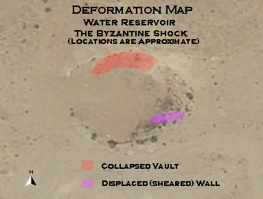
| Displaced Wall | SE wall of the water reservoir Water Reservoir at Rehovot ba Negev on govmap.gov.il
click on image to explore this site on a new tab in govmap.gov.il |
Fig. 18 Rehovot-ba-Negev, seismogenic (?) rupture at the SE wall of the water reservoir. The reservoir was partly cut out of the bedrock and is partly brick-built. Also note the collapse of a significant part of the armored layer which partly covered the reservoir from SW Korzhenkov and Mazor (2014) |
|
| Vault Collapse - Ceiling collapse | Water reservoir
Water Reservoir at Rehovot ba Negev on govmap.gov.il click on image to explore this site on a new tab in govmap.gov.il |
Fig. 18 Rehovot-ba-Negev, seismogenic (?) rupture at the SE wall of the water reservoir. The reservoir was partly cut out of the bedrock and is partly brick-built. Also note the collapse of a significant part of the armored layer which partly covered the reservoir from SW Korzhenkov and Mazor (2014)
Fig. 4Rehovot: a panoramic view of the reservoir Rubin (1988) |
|
| Effect | Location | Image(s) | Description |
|---|---|---|---|
| Arch and Roof Collapse | Room L.206 in Southern Quarter (Area B)
Fig. 1 Plan of Area B Tsafrir and Holum (1988) |
 III.14
Fallen Arches and roofing slabs in room L.206 looking south JW: This is in Residential Buildings in the Southern Quarter (Area B) Tsafrir et al (1988) |
Because the finds did not include any characteristic forms of the 8th centuryTsafrir et al (1988:9) date roof collapse in a room in the southern quarter (Area B) to the early 8th century CE at the latest. |
| Vault Collapse | The Crypt of the Northern Church
Fig. 18 An isometric reconstruction of the crypt below the pavement of the church Tsafrir et al (1988)
A schematic plan of walls and loci
Tsafrir et al (1988) |
 III.80
Accumulation of the architectural parts in the crypt Tsafrir et al (1988)
Fig. 22A section of the accumulation of debris in the northern entrance into the crypt (L. 504). Tsafrir et al (1988) |
Tsafrir et al (1988:50)
found that the vault of the crypt in the Northern Church collapsed
and the staircases into the crypt and the crypt itself were filled with debris. The concentration of drums, capitals and other architectural elements, and the fragments of burial inscriptions that were found in the crypt cannot be seen as the culmination of a natural process of decay (III. 80). Five capitals were found, for instance, in the lower part of the debris, above the floor(Tsafrir et al, 1988). Korzhenkov and Mazor (2014) suggest that this was due to a seismic event and suggest two main stages of destruction in the Northern Church - first when the church columns collapsed in the 7th century event and then a second time when the vault of the crypt collapsed and the staircases filled with debris. |
| Arch and Roof Collapse and Debris | Room L 505 (?) of the Northern Church
A schematic plan of walls and loci
Tsafrir et al (1988) |
 III.87
Roofing slabs in room L. 505, looking northwest Tsafrir et al (1988) |
Further evidence of two phases of destruction was found, according to
Korzhenkov and Mazor (2014), in Room L 509
of the Northern Church where roof slabs were found atop a layer of debris
that was presumed to have been created by the earlier 7th century CE earthquake however
Tsafrir et al (1988:66) attribute debris and roof collapse in L.509
to decay that occurred over a long period of time. It is possible that Korzhenkov and Mazor (2014) meant Room L 505 of the Northern Church which was completely filled with earth and stones(Tsafrir et al, 1988:62) and was covered by a layer of roof slabs (Plate III.87). Tsafrir et al (1988) did not attribute destruction or debris in Room L 505 to a cause. Found in the debris of Room L 505 was an Umayyad coin minted at Ramla dated between 716 and 750 CE (Tsafrir et al, 1988:61). Sherds and glass from the floor level or close to it are common Byzantine types(Tsafrir et al, 1988:62). |
| Seismic Effect | Location | Figures | Comments |
|---|---|---|---|
| Tilted and Collapsed Wall | an unexcavated quarter |
 Fig. 9
Tilt and collapse of one of the walls at an unexcavated quarter Korzhenkov and Mazor (2014) |
At Rehovot-ba-Negev several measurements reveal the systematic failure of the walls in unexcavated quarters in certain directions: walls trending ~ 140º have fallen about 50º, and walls trending ~ 50º have collapsed ~ 140º (fig. 9)- Korzhenkov and Mazor (2014) |
| Collapsed Walls | Well-house, built under the British Mandate, above the ruins of the Byzantine bath house
Fig. 4 Musil's ground plan of the site Tsafrir et al (1988)
Fig. 6Lawrence and Woolley's ground plan of the site. Tsafrir et al (1988) |
Fig. 10 Destroyed well-house, built under the British Mandate, above the ruins of the Byzantine bath house Korzhenkov and Mazor (2014) |
The well-house, which was built during the British Mandate, is significantly destroyed (fig. 10)- Korzhenkov and Mazor (2014) |
| Damage Type | Location | Figure | Comments |
|---|---|---|---|
| Tilted Walls | Northern Church
Fig. 3 Plan of the Northern Church (north arrow added by JW) Korzhenkov and Mazor (2014) |
4
Fig. 4 A tilt southward of the southern wall at the SE premises of the Northern Church (field station 3). The degree of the tilting is increasing with the distance from the abutted perpendicular wall. This phenomenon is the result of maximum freedom of oscillation at the central part of the wall Korzhenkov and Mazor (2014) 5
Fig. 5An 18º-tilt and a collapse of the western wall westward at the SW corner of the western yard (field station 4). Opening between two perpendicular walls is shown by a double arrow, and a through-going fissure (joint) cuts three adjacent stones in succession (shown by three white arrows) Korzhenkov and Mazor (2014) 6
Fig. 6Tilt of the western wall toward WNW at field station 5. There is an opening between the tilted wall and the perpendicular one Korzhenkov and Mazor (2014) 7
Fig. 7A northward tilt of the original southern wall (field station 10). Note the open space between the mentioned wall and the perpendicular adjacent wall of a small room and the shifting of the upper part of the preserved revetment wall, also northward Korzhenkov and Mazor (2014) 8
Fig. 8A southward tilt of the whole wall of the Northern Church a: view toward east b: view towards ESE from above. The angle of tilt is increasing up along the wall (a "skyscraper" effect) Korzhenkov and Mazor (2014) |
At Rehovot-ba-Negev, the southern wall of the SE premises of the North Church (field station 3 in fig. 3) tilted southwards (fig. 4). The wall trend is 108°; declination azimuth is 198°; and the angle is up to 75°. Another example can be seen at the same premises (field station 3) where one can observe the same damage pattern in the western wall: the wall trend is 13°, tilted to 81° and collapsed westward — toward azimuth 283°. Only a few fragments are preserved of the western wall, and only one stone high. The wall continues northward. Here it has a tilt and a westward collapse analogous to the SW corner of the western yard in the North Church (field station 4 in fig. 3). The trend of the azimuth of the wall is 18°; it is tilted at an angle up to 72°; and the declination azimuth is 287°; this is also the direction of the wall collapse (fig. 5). The wall continues northward until it meets the opposite wall of the northern premises (field station 5 in fig. 3). It is tilted WNW at a maximum angle of 21° (fig. 6); the trend of the wall is 31°, and the declination azimuth is 301°. |
| Collapsed Walls | un-excavated quarter well-house |
9
Fig. 9 Tilt and collapse of one of the walls at an unexcavated quarter Korzhenkov and Mazor (2014) 10
Fig. 10Destroyed well-house, built under the British Mandate, above the ruins of the Byzantine bath house Korzhenkov and Mazor (2014) |
At Rehovot-ba-Negev several measurements reveal the systematic failure of the walls in unexcavated quarters in certain directions: walls trending — 140° have fallen about 50°, and walls trending — 50° have collapsed — 140° (fig. 9). |
| Deformed Arches and Roofs | Residential Building in S quarter Area B Room L.207 | 11
Fig. 11 Collapse of the arch in room L.207, which has been filled with earth before its complete collapse Korzhenkov and Mazor (2014) |
As mentioned above, the walls were not completely destroyed during the first shock that occurred in Late Roman times. The arches and roofs probably withstood the shock too, though many of them were significantly damaged (fig. 11). This is probably the reason why ancient people filled some of the rooms with earth in order to protect them from complete collapse. |
| Shifted Wall Fragments | Northern Church
Fig. 3 Plan of the Northern Church (north arrow added by JW) Korzhenkov and Mazor (2014) excavated quarters of the ancient city |
12
Fig. 12 Rehovot-ba-Negev, northward tilting and shifting of the southern wall of the Northern Church Korzhenkov and Mazor (2014) 13
Fig. 13A horizontal 15 cm shift eastward of the upper part of an arch column in one of the excavated quarters Korzhenkov and Mazor (2014) |
Above we wrote that the southern wall of the North Church (field station 10 in fig. 3) tilts northward (fig. 7); however, there is also shifting (10-15 cm) of the upper row of the stones in the same direction (fig. 12). |
| Walls Deformed as a Result of Pushing by an Adjacent Perpendicular Wall | Northern Church
Fig. 3 Plan of the Northern Church (north arrow added by JW) Korzhenkov and Mazor (2014) Stables of the Caravansary |
14
Fig. 14 Deformation of two perpendicular walls at the Caravansary, the "feeding" wall pushed the perpendicular one. The later wall is significantly tilted. The "feeding" wall is also deformed: there are some openings in its upper part and joints (shown by arrows) crossing two stones are in the wall’s lower part Korzhenkov and Mazor (2014) |
The pushing of walls by a connected perpendicular wall has been identified as one of the seismic damage patterns at Mamshit - one of the ancient towns of the Negev desert, east of Rehovot-ba-Negev. At Rehovot-ba-Negev we find such an example at the SW corner of the large premises of the North Church (field station 2 in fig. 3), where three stones at the upper part of the wall have been moved, probably due to the push of an adjacent perpendicular wall. The trend of the deformed wall is 110°. The stones were shifted SSW (200°) at a distance of 12 cm. The perpendicular pushing wall has a trend of 24°. Another example can be observed at the SE premises of the North Church (field station 3 in fig. 3). There the northern wall (trend 115°) pushed the perpendicular western wall (trend 13°) westward. |
| Opening between Adjacent Perpendicular Walls | Northern Church
Fig. 3 Plan of the Northern Church (north arrow added by JW) Korzhenkov and Mazor (2014) |
15
Fig. 15 Opening between two adjacent perpendicular walls at the SE premises (field station 3) Korzhenkov and Mazor (2014) 5
Fig. 5An 18º-tilt and a collapse of the western wall westward at the SW corner of the western yard (field station 4). Opening between two perpendicular walls is shown by a double arrow, and a through-going fissure (joint) cuts three adjacent stones in succession (shown by three white arrows) Korzhenkov and Mazor (2014) 6
Fig. 6Tilt of the western wall toward WNW at field station 5. There is an opening between the tilted wall and the perpendicular one Korzhenkov and Mazor (2014) |
The pushing of a wall by an adjacent perpendicular one is quite common. The pushed wall is usually tilted or/and collapsed. Between this tilted wall and the perpendicular one (the pusher) an open space is often formed. This could also be due to the especial vulnerability of corners to large seismic shocks, because wave-parallel and wave-orthogonal walls oscillate at different amplitudes and frequencies. Ordinary old buildings often lack coupling elements between adjacent walls, and long-lasting strong seismic oscillation often causes gaps (or long open cracks) which may lead to the failure of corners. |
| Rotations of Wall Fragments | Northern Church
Fig. 3 Plan of the Northern Church (north arrow added by JW) Korzhenkov and Mazor (2014) |
16
Fig. 16 Clockwise rotation of a stone in an eastern wall (field station 9) Korzhenkov and Mazor (2014) |
The rotation of wall fragments around a vertical axis is a common phenomenon during strong earthquakes. Foundation stones are pulled out and rotated, indicating dynamic beating in the process of sharp horizontal oscillations of the whole wall (and not only its upper part). A seismic ground motion is the only mechanism that can cause rotation of building elements. A large number of observed rotations, and the obvious directional systematics, support this conclusion. An example of rotation (fig. 16) can be observed outside the eastern wall of the North Church (field station 9 in fig. 3). Here one stone in the upper preserved row was rotated clockwise. The general trend of the wall is 24°; and the trend of the rotated block is 26°. |
| Wall Crossing Fissures (Joints) | Northern Church
Fig. 3 Plan of the Northern Church (north arrow added by JW) Korzhenkov and Mazor (2014) |
17
Fig. 17 Rehovot-ba-Negev, joints at the wall at the southern entrance into the Northern Church (field station 1) cut through three stones Korzhenkov and Mazor (2014) 5
Fig. 5An 18º-tilt and a collapse of the western wall westward at the SW corner of the western yard (field station 4). Opening between two perpendicular walls is shown by a double arrow, and a through-going fissure (joint) cuts three adjacent stones in succession (shown by three white arrows) Korzhenkov and Mazor (2014) |
Many researchers mentioned that deformation of through-the-wall fissures at archaeological sites were caused by ancient earthquakes. Indeed, fissures crossing adjacent stones are the strongest evidence of the seismic origin of these deformations. Such through-going fissures are only formed as a result of high intensity earthquakes, as high energy is necessary to overcome the stress shadow of free surfaces at the stone margins, i. e., the free space between adjacent stones. |
| A Crack Crossing through the Wall at the Water Reservoir | Water Reservoir | 18
Fig. 18 Rehovot-ba-Negev, seismogenic (?) rupture at the SE wall of the water reservoir. The reservoir was partly cut out of the bedrock and is partly brick-built. Also note the collapse of a significant part of the armored layer which partly covered the reservoir from SW Korzhenkov and Mazor (2014) |
A through-the-wall crack was observed at the Rehovot-ba-Negev water reservoir. The whole wall is cut by this rupture (fig. 18), resembling a "pure" seismic rupture with a horizontal displacement (left-lateral shift) on the first ten centimeters. However, this rupture does not continue in either the adjacent ancient building constructions, or in the relief features. Additional study, and palaeoseismological trenching of the rupture is necessary. The described rupture could be the reason for the disappearance of the water resource in the town, and its subsequent abandonment. |
| revetment Walls | Northern Church
Fig. 3 Plan of the Northern Church (north arrow added by JW) Korzhenkov and Mazor (2014) |
19
Fig. 19 A deformed northern wall is supported by a revetment wall (field station 6). A strong deformation of the original wall is seen by wide openings between stones and a tilted block at the central part of the Figure Korzhenkov and Mazor (2014) 20
Fig. 20Continuation of the revetment wall (field station 7) Korzhenkov and Mazor (2014) 21
Fig. 21Revetment wall at the NE corner Korzhenkov and Mazor (2014) |
Sloping support walls have been found in the North and South Churches and in private buildings. The core of the revetment is a combination of small rough stones and earth, with a layer of larger roughly-dressed stones on the outside. The revetment is cemented by grey mortar, consisting of chalk and ashes. The revetment wall is laid on the virgin loess. The wall reaches 1.80 m in height and is 90 cm wide at the base. The whole northern wall of the big courtyard (field station 6 in fig. 3) of the North Church is surrounded by the revetment wall (fig. 19), its half was demolished at present time. The revetment wall continues around the northern room (field station 7 in fig. 3) of the main premises of the North Church (fig. 20). At the NE corner of the North Church, one can observe the continuation of an encircling revetment wall (field station 8 in fig. 3). At this corner the wall is destroyed (fig. 21), with the stones collapsing northwards on an original wall. The encircling revetment wall is of good quality. The destruction event (an earthquake), which deformed the original wall, occurred before the decline of the Byzantine Empire. There was then another seismic event which led to the destruction of the revetment wall itself. The last event was probably an end of "civilized" life here. |
| Columns Supported by Walls | Northern Church
Fig. 3 Plan of the Northern Church (north arrow added by JW) Korzhenkov and Mazor (2014) |
22
Fig. 22 Rehovot-ba-Negev, Northern Church. An ancient column within a wall that was built in order to protect it from possible future destruction Korzhenkov and Mazor (2014) |
Columns at ancient and modern buildings cause the redistribution of the static load of the whole building construction, and serve as art decoration of the internal and external parts of the building. When a researcher finds a column supported by a later wall, he can be sure that the column was severely deformed, making the supporting wall necessary. Such an example can be found in the North Church (fig. 22). |
| Features of Later Repair and Rebuilding | Northern Church
Fig. 3 Plan of the Northern Church (north arrow added by JW) Korzhenkov and Mazor (2014) |
Tsafrir et al. wrote that when the revetment wall was built around the church it closed the entrance to one room. A new threshold was installed which was about 60 cm above the former floor level. No remains of steps inside the room were found. This means that after the first earthquake the floor was covered by debris, which was not cleaned, but leveled, requiring a new threshold. |
|
| Secondary Use of Stones from Destroyed Walls | Room L 522 Northern Church's chapel
Fig. 3Plan of the Northern Church (north arrow added by JW) Korzhenkov and Mazor (2014) |
Secondary use of stones from damaged and destroyed walls is a common feature at the cities that experienced strong earthquakes. For example, a large fragment of a water basin was found in an Early Arab secondary wall at the east end of the porch (Room L 522). Another secondary wall was discovered at the eastern porch of the atrium behind the stylobate and preserved it at a height of two-three rows, which blocked the atrium from the west. |
- Modified by JW from Fig. 3 of Korzhenkov and Mazor (2014) (left) and Fig. 1 of Tsafrir & Holum (1988) (right)

 Deformation Map
modified by JW from Fig. 3 of Korzhenkov and Mazor (2014) (left) and Fig. 1 of Tsafrir & Holum (1988) (right)
- Modified by JW from Fig. 3 of Korzhenkov and Mazor (2014) (left) and GovMapIL (right)

 Deformation Map
modified by JW from Fig. 3 of Korzhenkov and Mazor (2014) (left) and GovMapIL (right)
- Modified by JW from Fig. 11 of Tsafrir et al (1988) (left) and Fig. 1 of Tsafrir & Holum (1988) (right)

 Deformation Map
modified by JW from Fig. 11 of Tsafrir et al (1988) (left) and Fig. 1 of Tsafrir & Holum (1988) (right)
- Earthquake Archeological Effects chart
of Rodríguez-Pascua et al (2013: 221-224)
 Earthquake Archeological Effects (EAE)
Rodríguez-Pascua et al (2013: 221-224)
| Seismic Effect | Location | Figure(s) | Comments | Intensity |
|---|---|---|---|---|
| Tilted wall | Southern Wall of Northern Church - Station 10
Fig. 3 Plan of the Northern Church (north arrow added by JW) Korzhenkov and Mazor (2014) |
Fig. 7 A northward tilt of the original southern wall (field station 10). Note the open space between the mentioned wall and the perpendicular adjacent wall of a small room and the shifting of the upper part of the preserved revetment wall, also northward Korzhenkov and Mazor (2014) |
|
VI+ |
| Tilted wall | Northern Wall of Northern Church - Station 12
Fig. 3 Plan of the Northern Church (north arrow added by JW) Korzhenkov and Mazor (2014) |
Fig. 8 A southward tilt of the whole wall of the Northern Church
The angle of tilt is increasing up along the wall (a "skyscraper" effect) Korzhenkov and Mazor (2014) |
The whole northern wall of the Church (field station 12 in fig. 3) has a significant tilt to the south (figs. 8 a. b)- Korzhenkov and Mazor (2014) |
VI+ |
| Displaced walls | Southern Wall of Northern Church - Station 10
Fig. 3 Plan of the Northern Church (north arrow added by JW) Korzhenkov and Mazor (2014) |
Fig. 12 Rehovot-ba-Negev, northward tilting and shifting of the southern wall of the Northern Church Korzhenkov and Mazor (2014) |
there is also shifting (10–15 cm) of the upper row of the stones [of the southern wall of the northern church] in the same direction [northward] (fig. 12).- Korzhenkov and Mazor (2014) |
VII+ |
| Folded Wall - Deformed wall supported by a revetment wall | Northern Wall of of the big courtyard (i.e. the atrium) of the Northern Church - Station 6
Fig. 3 Plan of the Northern Church (north arrow added by JW) Korzhenkov and Mazor (2014) |
Fig. 19 A deformed northern wall is supported by a revetment wall (field station 6). A strong deformation of the original wall is seen by wide openings between stones and a tilted block at the central part of the Figure Korzhenkov and Mazor (2014) |
Sloping support walls have been found in the North and South Churches and in private buildings. The core of the revetment is a combination of small rough stones and earth, with a layer of larger roughly-dressed stones on the outside. The revetment is cemented by grey mortar, consisting of chalk and ashes. The revetment wall is laid on the virgin loess. The wall reaches 1.80 m in height and is 90 cm wide at the base. The whole northern wall of the big courtyard (field station 6 in fig. 3) of the North Church is surrounded by the revetment wall (fig. 19), its half was demolished at present time.- Korzhenkov and Mazor (2014) |
VII+ |
| Folded Wall - Deformed wall supported by a revetment wall | Northern Wall of Northern Church - Station 7
Fig. 3 Plan of the Northern Church (north arrow added by JW) Korzhenkov and Mazor (2014) |
Fig. 20 Continuation of the revetment wall (field station 7) Korzhenkov and Mazor (2014) |
The revetment wall continues around the northern room (field station 7 in fig. 3) of the main premises of the North Church (fig. 20)- Korzhenkov and Mazor (2014) |
VII+ |
| revetment walls indicating displaced and folded walls | NE corner of the Northern Church - Station 8
Fig. 3 Plan of the Northern Church (north arrow added by JW) Korzhenkov and Mazor (2014) |
|
At the NE corner of the North Church, one can observe the continuation of an encircling revetment wall (field station 8 in fig. 3). At this corner the wall is destroyed (fig. 21), with the stones collapsing northwards on an original wall. The encircling revetment wall is of good quality. The destruction event (an earthquake), which deformed the original wall, occurred before the decline of the Byzantine Empire. There was then another seismic event which led to the destruction of the revetment wall itself. The last event was probably an end of ›civilized‹ life here.- Korzhenkov and Mazor (2014) |
VII+ |
| Deformation of arches and roofs | Room L.207 in Area B
Fig. 2 A ground plan for Area B Tsafrir et al (1988)
Fig. 1Plan of Area B Tsafrir and Holum (1988) |
Fig. 11 Collapse of the arch in room L.207, which has been filled with earth before its complete collapse Korzhenkov and Mazor (2014) |
the walls were not completely destroyed during the first shock that occurred in Late Roman times. The arches and roofs probably withstood the shock too, though many of them were significantly damaged (fig. 11). This is probably the reason why ancient people filled some of the rooms with earth in order to protect them from complete collapse.- Korzhenkov and Mazor (2014) |
VI+ |
- Fig. 9 - Tilted and
and collapsed walls in the unexcavated quater from Korzhenkov and Mazor (2014)
Fig. 9
Tilt and collapse of one of the walls at an unexcavated quarter
Korzhenkov and Mazor (2014) - Fig. 23 - Schematic
drawing of directions of tilt and collapse in the unexcavated quarters from Korzhenkov and Mazor (2014)
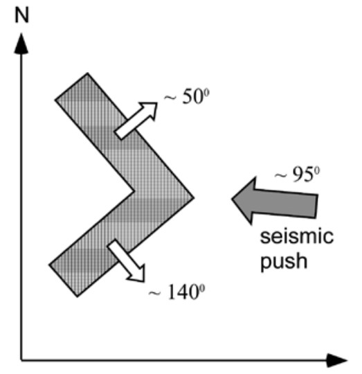 Fig. 23
The scheme shows directions of tilts and collapses in Rehovot-ba-Negev at unexcavated quarters. SE-oriented walls are tilted and collapsed toward NE, while NE-oriented walls are tilted and collapsed toward SW. In order to produce such damage patterns it was necessary to involve seismic shocks coming from the east
Korzhenkov and Mazor (2014) - Fig. 1 - Map of intensity estimates
in the Negev from Korzhenkov and Mazor (2014)
 Fig. 1
The ancient caravan routes (thick lines) in the Negev desert, the intensities of the seismic oscillations (according to MSK-64 scale) of past earthquakes in the old cities studied by the authors are shown (scale 1 : 1 500 000)
Korzhenkov and Mazor (2014)
Korzhenkov and Mazor (2014) estimated the same Intensity (VIII–IX) for 4 seismic events ("Late Roman Earthquake", "The Byzantine Shock", "Post Abandonment Quake", and Turkish/British Earthquake(s)) and the same direction of the epicenter (ESE).
There are few measurements of tilted and fallen walls, small remnants of which are still projected above the surface (fig. 9). Generally these walls tilted or collapsed toward ESE (fig. 23).
The degree of destruction at all the studied cities of the Negev desert (Avdat, Haluza, Mamshit, Rehovot-ba-Negev and Shivta) is similar (fig. 1). In order to produce such deformations, the local seismic intensity would have had to be I > VIII. In our previous papers we came to the conclusion that most of these deformations were caused by the local faults which dissect the Negev, and not the Dead Sea Transform. If it would be the case of the Dead Sea Transform, the degree of deformations would decreased from Mamshit in the east (maximum) to Rehovot-ba-Negev in the west. However, the degree of seismic deformation is not damping westward.
Recent geological research has revealed the existence of a strike-slip fault, the Saadon fault next to the site of Saadon, and close to Rehovot-ba-Negev. A dry river Nahal Saadon follows the strike of the fault and is incised into the chalk layers of the uplifted geological block. The fault strikes N65 degrees W, dipping steeply to the northeast, and is between 0.5–1.0 km of long, with a vertical displacement of 2–3 m43. This fault, as well as other adjacent faults (Sde-Boker, Nafha, Ramon, Paran faults), could be the source of the seismic oscillations which destroyed Rehovot ba-Negev as well as other adjacent ancient desert cities.
Thus our archaeoseismological study of the ruins at ancient Rehovot-ba-Negev has revealed numerous features of seismic destructions, which testify to at least four earthquakes that affected the ancient town. The seismic intensities of these ancient seismic events were in the range of I = VIII–IX. This data confirms similar results in the adjacent ancient cities of the Negev desert – Avdat, Haluza, Mamshit and Shivta.
- Earthquake Archeological Effects chart
of Rodríguez-Pascua et al (2013: 221-224)
Earthquake Archeological Effects (EAE)
Rodríguez-Pascua et al (2013: 221-224)
| Seismic Effect | Location | Figures | Comments | Intensity |
|---|---|---|---|---|
| Tilted Wall | Southern wall at the SE premises of the Northern Church - Station 3
Fig. 3 Plan of the Northern Church (north arrow added by JW) Korzhenkov and Mazor (2014) |
Fig. 4 A tilt southward of the southern wall at the SE premises of the Northern Church (field station 3). The degree of the tilting is increasing with the distance from the abutted perpendicular wall. This phenomenon is the result of maximum freedom of oscillation at the central part of the wall Korzhenkov and Mazor (2014) |
the southern wall of the SE premises of the North Church (field station 3 in fig. 3) tilted southwards (fig. 4). The wall trend is 108º; declination azimuth is 198º; and the angle is up to 75º.- Korzhenkov and Mazor (2014) |
VI+ |
| tilted and collapsed (?) wall | Western wall at the SW end of the western yard of the Northern Church - Stations 3 & 4
Fig. 3 Plan of the Northern Church (north arrow added by JW) Korzhenkov and Mazor (2014) |
Fig. 5 An 18º-tilt and a collapse of the western wall westward at the SW corner of the western yard (field station 4). Opening between two perpendicular walls is shown by a double arrow, and a through-going fissure (joint) cuts three adjacent stones in succession (shown by three white arrows) Korzhenkov and Mazor (2014) |
Another example can be seen at the same premises (field station 3) where one can observe the same damage pattern in the western wall: the wall trend is 13º, tilted to 81º and collapsed westward – toward azimuth 283º. Only a few fragments are preserved of the western wall, and only one stone high. The [western] wall continues northward. Here it has a tilt and a westward collapse analogous to the SW corner of the western yard in the North Church (field station 4 in fig. 3). The trend of the azimuth of the wall is 18º; it is tilted at an angle up to 72º; and the declination azimuth is 287º; this is also the direction of the wall collapse (fig. 5).- Korzhenkov and Mazor (2014) |
VI+ or VIII+ (?) |
| Tilted Wall | Western wall of the Northern Church - Station 5
Fig. 3 Plan of the Northern Church (north arrow added by JW) Korzhenkov and Mazor (2014) |
Fig. 6 Tilt of the western wall toward WNW at field station 5. There is an opening between the tilted wall and the perpendicular one Korzhenkov and Mazor (2014) |
|
VI+ |
| Tilted Wall | Southern wall of the Northern Church - Station 10
Fig. 3 Plan of the Northern Church (north arrow added by JW) Korzhenkov and Mazor (2014) |
Fig. 7 A northward tilt of the original southern wall (field station 10). Note the open space between the mentioned wall and the perpendicular adjacent wall of a small room and the shifting of the upper part of the preserved revetment wall, also northward Korzhenkov and Mazor (2014) |
The southern wall of the North Church (field station 10 in fig. 3) is tilted northward (fig. 7).The trend of the wall is 202º, and the maximum tilt angle is 77º. Because of this tilt one can observe an open space between the southern wall and the adjacent perpendicular one. The existence of revetment walls, supporting the southern wall of the Church from the south, indicates that the southern wall’s tilt occurred during the first of the Late Roman earthquakes. It seems that the southern wall began to tilt northward inside the building during the Early Arab earthquakes; additional evidence for this is the shift northwards of the upper part of the revetment wall. Stones of the perpendicular eastern wall are cracked in the small room marked on the plan. Nevertheless, this wall is better preserved (it is much higher) than the main southern wall of the North Church. This indicates that the seismic shocks during both earthquakes acted perpendicular to the main Church wall: it had freedom of oscillation and was significantly destroyed.- Korzhenkov and Mazor (2014) |
VI+ |
| Displaced Masonry Blocks | upper part of an arch column in one of the excavated quarters |
Fig. 13 A horizontal 15 cm shift eastward of the upper part of an arch column in one of the excavated quarters Korzhenkov and Mazor (2014) |
a 15 cm shift eastward of two stones in the upper part of an arch column (fig. 13) in one of the excavated quarters of the ancient city. The arch above collapsed during the Byzantine shocks.- Korzhenkov and Mazor (2014) |
VIII+ |
| Displaced Masonry Blocks - Rotated Stone | Eastern wall of the Northern Church - Station 9
Fig. 3 Plan of the Northern Church (north arrow added by JW) Korzhenkov and Mazor (2014) |
Fig. 16 Clockwise rotation of a stone in an eastern wall (field station 9) Korzhenkov and Mazor (2014) |
The rotation of wall fragments around a vertical axis is a common phenomenon during strong earthquakes. Foundation stones are pulled out and rotated, indicating dynamic beating in the process of sharp horizontal oscillations of the whole wall (and not only its upper part). A seismic ground motion is the only mechanism that can cause rotation of building elements. A large number of observed rotations, and the obvious directional systematics, support this conclusion. An example of rotation (fig. 16) can be observed outside the eastern wall of the North Church (field station 9 in fig. 3). Here one stone in the upper preserved row was rotated clockwise. The general trend of the wall is 24º; and the trend of the rotated block is 26º.- Korzhenkov and Mazor (2014) |
VIII+ |
| Displaced Masonry Blocks - Pushing of a wall by an adjacent perpendicular wall | Area C (The Khan)
Fig. 3 Plan of Area C; the stable buildings Tsafrir and Holum (1988) |
Fig. 14 Deformation of two perpendicular walls at the Caravansary, the "feeding" wall pushed the perpendicular one. The later wall is significantly tilted. The "feeding" wall is also deformed: there are some openings in its upper part and joints (shown by arrows) crossing two stones are in the wall’s lower part Korzhenkov and Mazor (2014) |
The pushing of walls by a connected perpendicular wall has been identified as one of the seismic damage patterns at Mamshit – one of the ancient towns of the Negev desert, east of Rehovot-ba-Negev. ... A similar picture can be observed at the stables of the Caravansary (fig. 14). Here the ›feeding‹ wall pushed a perpendicular one. Both walls are significantly deformed, tilted (declination angle 22º) and crossed by joints.- Korzhenkov and Mazor (2014) |
VIII+ |
| Displaced Masonry Blocks - Opening between two adjacent perpendicular walls | Western wall of the Northern Church - Station 4
Fig. 3 Plan of the Northern Church (north arrow added by JW) Korzhenkov and Mazor (2014) |
Fig. 5 An 18º-tilt and a collapse of the western wall westward at the SW corner of the western yard (field station 4). Opening between two perpendicular walls is shown by a double arrow, and a through-going fissure (joint) cuts three adjacent stones in succession (shown by three white arrows) Korzhenkov and Mazor (2014) |
|
VIII+ |
| Tilted Wall - Opening between two adjacent perpendicular walls | Western wall of the Northern Church - Station 5
Fig. 3 Plan of the Northern Church (north arrow added by JW) Korzhenkov and Mazor (2014) |
Fig. 6 Tilt of the western wall toward WNW at field station 5. There is an opening between the tilted wall and the perpendicular one Korzhenkov and Mazor (2014) |
|
VI+ |
| Tilted Wall - Opening between two adjacent perpendicular walls | Western wall of the Northern Church - Station 3
Fig. 3 Plan of the Northern Church (north arrow added by JW) Korzhenkov and Mazor (2014) |
Fig. 15 Opening between two adjacent perpendicular walls at the SE premises (field station 3) Korzhenkov and Mazor (2014) |
The pushing of a wall by an adjacent perpendicular one is quite common. The pushed wall is usually tilted or/and collapsed. Between this tilted wall and the perpendicular one (the pusher) an open space is often formed. This could also be due to the especial vulnerability of corners to large seismic shocks, because wave-parallel and wave-orthogonal walls oscillate at different amplitudes and frequencies. Ordinary old buildings often lack coupling elements between adjacent walls, and long-lasting strong seismic oscillation often causes gaps (or long open cracks) which may lead to the failure of corners.- Korzhenkov and Mazor (2014) |
VI+ |
| Penetrative fractures in masonry blocks - through-going joints | Western wall of the Northern Church - Station 4
Fig. 3 Plan of the Northern Church (north arrow added by JW) Korzhenkov and Mazor (2014) |
Fig. 5 An 18º-tilt and a collapse of the western wall westward at the SW corner of the western yard (field station 4). Opening between two perpendicular walls is shown by a double arrow, and a through-going fissure (joint) cuts three adjacent stones in succession (shown by three white arrows) Korzhenkov and Mazor (2014) |
|
VI+ (Note: Korzhenkov estimates much higher Intensity for this - ~IX) |
| Penetrative fractures in masonry blocks - through-going joints | Area C (The Khan)
Fig. 3 Plan of Area C; the stable buildings Tsafrir and Holum (1988) |
Fig. 14 Deformation of two perpendicular walls at the Caravansary, the "feeding" wall pushed the perpendicular one. The later wall is significantly tilted. The "feeding" wall is also deformed: there are some openings in its upper part and joints (shown by arrows) crossing two stones are in the wall’s lower part Korzhenkov and Mazor (2014) |
there are some openings in its upper part and joints (shown by arrows) crossing two stones are in the wall’s lower part- Korzhenkov and Mazor (2014) |
VI+ (Note: Korzhenkov estimates much higher Intensity for this - ~IX) |
| Penetrative fractures in masonry blocks - through-going joints | Wall to the right of the southern entrance into the Northern Church - Station 1
Fig. 3 Plan of the Northern Church (north arrow added by JW) Korzhenkov and Mazor (2014) |
Fig. 17 Rehovot-ba-Negev, joints at the wall at the southern entrance into the Northern Church (field station 1) cut through three stones Korzhenkov and Mazor (2014) |
|
VI+ (Note: Korzhenkov estimates much higher Intensity for this - ~IX) |
| Displaced Wall | SE wall of the water reservoir
Water Reservoir at Rehovot ba Negev on govmap.gov.il click on image to explore this site on a new tab in govmap.gov.il |
Fig. 18 Rehovot-ba-Negev, seismogenic (?) rupture at the SE wall of the water reservoir. The reservoir was partly cut out of the bedrock and is partly brick-built. Also note the collapse of a significant part of the armored layer which partly covered the reservoir from SW Korzhenkov and Mazor (2014) |
|
VII+ |
| Vault Collapse - Ceiling collapse | Water reservoir
Water Reservoir at Rehovot ba Negev on govmap.gov.il click on image to explore this site on a new tab in govmap.gov.il |
Fig. 18 Rehovot-ba-Negev, seismogenic (?) rupture at the SE wall of the water reservoir. The reservoir was partly cut out of the bedrock and is partly brick-built. Also note the collapse of a significant part of the armored layer which partly covered the reservoir from SW Korzhenkov and Mazor (2014)
Fig. 4Rehovot: a panoramic view of the reservoir Rubin (1988) |
|
VIII+ |
- Fig. 9 - Tilted and
and collapsed walls in the unexcavated quater from Korzhenkov and Mazor (2014)
Fig. 9
Tilt and collapse of one of the walls at an unexcavated quarter
Korzhenkov and Mazor (2014) - Fig. 23 - Schematic
drawing of directions of tilt and collapse in the unexcavated quarters from Korzhenkov and Mazor (2014)
Fig. 23
The scheme shows directions of tilts and collapses in Rehovot-ba-Negev at unexcavated quarters. SE-oriented walls are tilted and collapsed toward NE, while NE-oriented walls are tilted and collapsed toward SW. In order to produce such damage patterns it was necessary to involve seismic shocks coming from the east
Korzhenkov and Mazor (2014) - Fig. 1 - Map of intensity estimates
in the Negev from Korzhenkov and Mazor (2014)
Fig. 1
The ancient caravan routes (thick lines) in the Negev desert, the intensities of the seismic oscillations (according to MSK-64 scale) of past earthquakes in the old cities studied by the authors are shown (scale 1 : 1 500 000)
Korzhenkov and Mazor (2014)
Korzhenkov and Mazor (2014) estimated the same Intensity (VIII–IX) for 4 seismic events ("Late Roman Earthquake", "The Byzantine Shock", "Post Abandonment Quake", and Turkish/British Earthquake(s)) and the same direction of the epicenter (ESE).
There are few measurements of tilted and fallen walls, small remnants of which are still projected above the surface (fig. 9). Generally these walls tilted or collapsed toward ESE (fig. 23).
The degree of destruction at all the studied cities of the Negev desert (Avdat, Haluza, Mamshit, Rehovot-ba-Negev and Shivta) is similar (fig. 1). In order to produce such deformations, the local seismic intensity would have had to be I > VIII. In our previous papers we came to the conclusion that most of these deformations were caused by the local faults which dissect the Negev, and not the Dead Sea Transform. If it would be the case of the Dead Sea Transform, the degree of deformations would decreased from Mamshit in the east (maximum) to Rehovot-ba-Negev in the west. However, the degree of seismic deformation is not damping westward.
Recent geological research has revealed the existence of a strike-slip fault, the Saadon fault next to the site of Saadon, and close to Rehovot-ba-Negev. A dry river Nahal Saadon follows the strike of the fault and is incised into the chalk layers of the uplifted geological block. The fault strikes N65 degrees W, dipping steeply to the northeast, and is between 0.5–1.0 km of long, with a vertical displacement of 2–3 m43. This fault, as well as other adjacent faults (Sde-Boker, Nafha, Ramon, Paran faults), could be the source of the seismic oscillations which destroyed Rehovot ba-Negev as well as other adjacent ancient desert cities.
Thus our archaeoseismological study of the ruins at ancient Rehovot-ba-Negev has revealed numerous features of seismic destructions, which testify to at least four earthquakes that affected the ancient town. The seismic intensities of these ancient seismic events were in the range of I = VIII–IX. This data confirms similar results in the adjacent ancient cities of the Negev desert – Avdat, Haluza, Mamshit and Shivta.
- Earthquake Archeological Effects chart
of Rodríguez-Pascua et al (2013: 221-224)
Earthquake Archeological Effects (EAE)
Rodríguez-Pascua et al (2013: 221-224)
| Effect | Location | Image(s) | Description | Intensity |
|---|---|---|---|---|
| Arch and Roof Collapse | Room L.206 in Southern Quarter (Area B)
Fig. 1 Plan of Area B Tsafrir and Holum (1988) |
III.14 Fallen Arches and roofing slabs in room L.206 looking south JW: This is in Residential Buildings in the Southern Quarter (Area B) Tsafrir et al (1988) |
Because the finds did not include any characteristic forms of the 8th centuryTsafrir et al (1988:9) date roof collapse in a room in the southern quarter (Area B) to the early 8th century CE at the latest. |
VI+ |
| Vault Collapse | The Crypt of the Northern Church
Fig. 18 An isometric reconstruction of the crypt below the pavement of the church Tsafrir et al (1988)
A schematic plan of walls and loci
Tsafrir et al (1988) |
III.80 Accumulation of the architectural parts in the crypt Tsafrir et al (1988)
Fig. 22A section of the accumulation of debris in the northern entrance into the crypt (L. 504). Tsafrir et al (1988) |
Tsafrir et al (1988:50)
found that the vault of the crypt in the Northern Church collapsed
and the staircases into the crypt and the crypt itself were filled with debris. The concentration of drums, capitals and other architectural elements, and the fragments of burial inscriptions that were found in the crypt cannot be seen as the culmination of a natural process of decay (III. 80). Five capitals were found, for instance, in the lower part of the debris, above the floor(Tsafrir et al, 1988). Korzhenkov and Mazor (2014) suggest that this was due to a seismic event and suggest two main stages of destruction in the Northern Church - first when the church columns collapsed in the 7th century event and then a second time when the vault of the crypt collapsed and the staircases filled with debris. |
VIII+ |
| Arch and Roof Collapse and Debris | Room L 505 (?) of the Northern Church
A schematic plan of walls and loci
Tsafrir et al (1988) |
III.87 Roofing slabs in room L. 505, looking northwest Tsafrir et al (1988) |
Further evidence of two phases of destruction was found, according to
Korzhenkov and Mazor (2014), in Room L 509
of the Northern Church where roof slabs were found atop a layer of debris
that was presumed to have been created by the earlier 7th century CE earthquake however
Tsafrir et al (1988:66) attribute debris and roof collapse in L.509
to decay that occurred over a long period of time. It is possible that Korzhenkov and Mazor (2014) meant Room L 505 of the Northern Church which was completely filled with earth and stones(Tsafrir et al, 1988:62) and was covered by a layer of roof slabs (Plate III.87). Tsafrir et al (1988) did not attribute destruction or debris in Room L 505 to a cause. Found in the debris of Room L 505 was an Umayyad coin minted at Ramla dated between 716 and 750 CE (Tsafrir et al, 1988:61). Sherds and glass from the floor level or close to it are common Byzantine types(Tsafrir et al, 1988:62). |
VI+ |
- Fig. 9 - Tilted and
and collapsed walls in the unexcavated quater from Korzhenkov and Mazor (2014)
Fig. 9
Tilt and collapse of one of the walls at an unexcavated quarter
Korzhenkov and Mazor (2014) - Fig. 23 - Schematic
drawing of directions of tilt and collapse in the unexcavated quarters from Korzhenkov and Mazor (2014)
Fig. 23
The scheme shows directions of tilts and collapses in Rehovot-ba-Negev at unexcavated quarters. SE-oriented walls are tilted and collapsed toward NE, while NE-oriented walls are tilted and collapsed toward SW. In order to produce such damage patterns it was necessary to involve seismic shocks coming from the east
Korzhenkov and Mazor (2014) - Fig. 1 - Map of intensity estimates
in the Negev from Korzhenkov and Mazor (2014)
Fig. 1
The ancient caravan routes (thick lines) in the Negev desert, the intensities of the seismic oscillations (according to MSK-64 scale) of past earthquakes in the old cities studied by the authors are shown (scale 1 : 1 500 000)
Korzhenkov and Mazor (2014)
Korzhenkov and Mazor (2014) estimated the same Intensity (VIII–IX) for 4 seismic events ("Late Roman Earthquake", "The Byzantine Shock", "Post Abandonment Quake", and Turkish/British Earthquake(s)) and the same direction of the epicenter (ESE).
There are few measurements of tilted and fallen walls, small remnants of which are still projected above the surface (fig. 9). Generally these walls tilted or collapsed toward ESE (fig. 23).
The degree of destruction at all the studied cities of the Negev desert (Avdat, Haluza, Mamshit, Rehovot-ba-Negev and Shivta) is similar (fig. 1). In order to produce such deformations, the local seismic intensity would have had to be I > VIII. In our previous papers we came to the conclusion that most of these deformations were caused by the local faults which dissect the Negev, and not the Dead Sea Transform. If it would be the case of the Dead Sea Transform, the degree of deformations would decreased from Mamshit in the east (maximum) to Rehovot-ba-Negev in the west. However, the degree of seismic deformation is not damping westward.
Recent geological research has revealed the existence of a strike-slip fault, the Saadon fault next to the site of Saadon, and close to Rehovot-ba-Negev. A dry river Nahal Saadon follows the strike of the fault and is incised into the chalk layers of the uplifted geological block. The fault strikes N65 degrees W, dipping steeply to the northeast, and is between 0.5–1.0 km of long, with a vertical displacement of 2–3 m43. This fault, as well as other adjacent faults (Sde-Boker, Nafha, Ramon, Paran faults), could be the source of the seismic oscillations which destroyed Rehovot ba-Negev as well as other adjacent ancient desert cities.
Thus our archaeoseismological study of the ruins at ancient Rehovot-ba-Negev has revealed numerous features of seismic destructions, which testify to at least four earthquakes that affected the ancient town. The seismic intensities of these ancient seismic events were in the range of I = VIII–IX. This data confirms similar results in the adjacent ancient cities of the Negev desert – Avdat, Haluza, Mamshit and Shivta.
- Earthquake Archeological Effects chart
of Rodríguez-Pascua et al (2013: 221-224)
Earthquake Archeological Effects (EAE)
Rodríguez-Pascua et al (2013: 221-224)
| Seismic Effect | Location | Figures | Comments | Intensity |
|---|---|---|---|---|
| Tilted and Collapsed Wall | an unexcavated quarter |
Fig. 9 Tilt and collapse of one of the walls at an unexcavated quarter Korzhenkov and Mazor (2014) |
At Rehovot-ba-Negev several measurements reveal the systematic failure of the walls in unexcavated quarters in certain directions: walls trending ~ 140º have fallen about 50º, and walls trending ~ 50º have collapsed ~ 140º (fig. 9)- Korzhenkov and Mazor (2014) |
VI+ and VIII+ |
| Collapsed Walls | Well-house, built under the British Mandate, above the ruins of the Byzantine bath house
Fig. 4 Musil's ground plan of the site Tsafrir et al (1988)
Fig. 6Lawrence and Woolley's ground plan of the site. Tsafrir et al (1988) |
Fig. 10 Destroyed well-house, built under the British Mandate, above the ruins of the Byzantine bath house Korzhenkov and Mazor (2014) |
The well-house, which was built during the British Mandate, is significantly destroyed (fig. 10)- Korzhenkov and Mazor (2014) |
VIII+ |
- Fig. 9 - Tilted and
and collapsed walls in the unexcavated quater from Korzhenkov and Mazor (2014)
Fig. 9
Tilt and collapse of one of the walls at an unexcavated quarter
Korzhenkov and Mazor (2014) - Fig. 23 - Schematic
drawing of directions of tilt and collapse in the unexcavated quarters from Korzhenkov and Mazor (2014)
Fig. 23
The scheme shows directions of tilts and collapses in Rehovot-ba-Negev at unexcavated quarters. SE-oriented walls are tilted and collapsed toward NE, while NE-oriented walls are tilted and collapsed toward SW. In order to produce such damage patterns it was necessary to involve seismic shocks coming from the east
Korzhenkov and Mazor (2014) - Fig. 1 - Map of intensity estimates
in the Negev from Korzhenkov and Mazor (2014)
Fig. 1
The ancient caravan routes (thick lines) in the Negev desert, the intensities of the seismic oscillations (according to MSK-64 scale) of past earthquakes in the old cities studied by the authors are shown (scale 1 : 1 500 000)
Korzhenkov and Mazor (2014)
Korzhenkov and Mazor (2014) estimated the same Intensity (VIII–IX) for 4 seismic events ("Late Roman Earthquake", "The Byzantine Shock", "Post Abandonment Quake", and Turkish/British Earthquake(s)) and the same direction of the epicenter (ESE).
There are few measurements of tilted and fallen walls, small remnants of which are still projected above the surface (fig. 9). Generally these walls tilted or collapsed toward ESE (fig. 23).
The degree of destruction at all the studied cities of the Negev desert (Avdat, Haluza, Mamshit, Rehovot-ba-Negev and Shivta) is similar (fig. 1). In order to produce such deformations, the local seismic intensity would have had to be I > VIII. In our previous papers we came to the conclusion that most of these deformations were caused by the local faults which dissect the Negev, and not the Dead Sea Transform. If it would be the case of the Dead Sea Transform, the degree of deformations would decreased from Mamshit in the east (maximum) to Rehovot-ba-Negev in the west. However, the degree of seismic deformation is not damping westward.
Recent geological research has revealed the existence of a strike-slip fault, the Saadon fault next to the site of Saadon, and close to Rehovot-ba-Negev. A dry river Nahal Saadon follows the strike of the fault and is incised into the chalk layers of the uplifted geological block. The fault strikes N65 degrees W, dipping steeply to the northeast, and is between 0.5–1.0 km of long, with a vertical displacement of 2–3 m43. This fault, as well as other adjacent faults (Sde-Boker, Nafha, Ramon, Paran faults), could be the source of the seismic oscillations which destroyed Rehovot ba-Negev as well as other adjacent ancient desert cities.
Thus our archaeoseismological study of the ruins at ancient Rehovot-ba-Negev has revealed numerous features of seismic destructions, which testify to at least four earthquakes that affected the ancient town. The seismic intensities of these ancient seismic events were in the range of I = VIII–IX. This data confirms similar results in the adjacent ancient cities of the Negev desert – Avdat, Haluza, Mamshit and Shivta.
- Fig. 11 - Wall models
from Rodkin and Korzhenkov (2018)
 Fig. 11
A sketch map showing the destruction of- an ideal rigid wall
- a more realistic wall composed of blocks of stones separated by joints
- Fig. 4 - Tilted wall
from Korzhenkov and Mazor (2014)
Fig. 4
A tilt southward of the southern wall at the SE premises of the Northern Church (field station 3). The degree of the tilting is increasing with the distance from the abutted perpendicular wall. This phenomenon is the result of maximum freedom of oscillation at the central part of the wall
Korzhenkov and Mazor (2014)
This method requires as input the Critical Tilt angle (α) of a wall in order for it to collapse. If the tilt is large enough, the projection of the wall's center of gravity will be located outside its base (see Fig. 11) and the wall will fall over. In order to estimate α, we need to come up with some wall dimensions - specifically Height and Thickness. For Rehovot ba-Negev, Rodkin and Korzhenkov (2018) estimated the following input values for Height and Thickness:
| Structure | Height (m) | Thickness (m) | Tilt Angle - α |
|---|---|---|---|
| Church | |||
| House |
Both cases lead to α between 11° and 12°. However, this tilt angle is for a rigid wall. If the wall is composed of blocks which are mortared together, as the seismic forces cause the wall to tilt, the top of the wall may start to bend and fail. If the top of the wall is destructed, the lower part of the wall will have a different effective geometry and require a larger tilt to fall over - perhaps between 15° and 20°. In fact, Rodkin and Korzhenkov (2018) note that this has been observed in Rehovot ba-Negev where tilt angles in the lower parts of wall can reach 15° and 20°. An example of such a phenomenon can be seen in Figure 4 of Korzhenkov and Mazor (2014). Thus, α can be constrained to between 11° and 20°. The other input variable is wall height H which is specified above as 5 meters for a church and 2.5 meters for a house. This leads to PGV values between 0.4 and 0.8 m/s for a church and 0.3 - 0.6 m/s for a house.
- Fig. 13 - Shifted stones
from Korzhenkov and Mazor (2014)
Fig. 13
A horizontal 15 cm shift eastward of the upper part of an arch column in one of the excavated quarters
Korzhenkov and Mazor (2014) - Fig. 16 - Shifted and rotated
stone from Korzhenkov and Mazor (2014)
Fig. 16
Clockwise rotation of a stone in an eastern wall (field station 9)
Korzhenkov and Mazor (2014)
The PGV Estimation Method also requires two inputs - the coefficient of friction (k) of the sliding masonry block and the observed displacement of the block. Rodkin and Korzhenkov (2018) estimated that k varied from 0.8 - 1.0 and displacement went as high as 10 - 15 cm. (the larger values are more important in their method). An example of the larger observed shift of ~15 cm. can be seen in Figure of 13 of Korzhenkov and Mazor (2014). Another example can be seen in Figure 16 . Although the PGV Estimation Method is their preferred method, there were apparently a limited number of displacement measurements in Rehovot ba-Negev. Thus, they included the Tilt method to help constrain reasonable PGV values. Inputting their suggested range of k values and displacement values leads to PGV values between 1.3 and 1.7 m/s - higher than what one obtains with the Tilt Method.
<