the largest to occur at the junction of the Dead Sea fault zone with the East Anatolian fault during the last five centuries. This may have been superseded by the 2023 Turkey-Syria Earthquakes. Like the 2023 Turkey-Syria Earthquakes, the 1822 CE Southeast Anatolia Quake may have consisted of multiple events. Ambraseys (2009) adds that
the shock almost entirely destroyed the region between Gaziantep and Antakya in Turkey and Aleppo and Han Sheikhun in northwestern Syria, killing a very large number of people.
 Figure 8
 Figure 6
 Figure 7
 Figure 1

 Figure 4
 Figure 5
 Table 2
 Table 1
 Table 4
 Figure 1
 Figure 1
 Figure 3
 Table 1
 Figure 10
 Figure 11
 Figure 5

Fig. 12 Map of intensity distribution for August 13, 1822 earthquake - Ambraseys (1989)

Fig. 13 Map of intensity distribution for August 13, 1822 earthquake - Sbeinati et al. (2005)
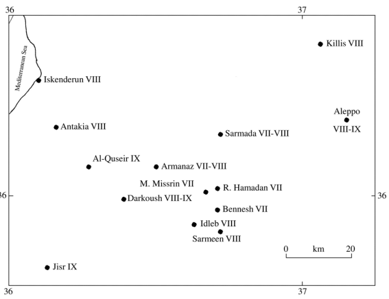
Fig. 14 Detailed map of intensity distribution for August 13, 1822 earthquake, between Antakia and Aleppo
- Sbeinati et al. (2005)
| Text (with hotlink) | Original Language | Biographical Info | Religion | Date of Composition | Location Composed | Notes |
|---|---|---|---|---|---|---|
| Text (with hotlink) | Original Language | Biographical Info | Religion | Date of Composition | Location Composed | Notes |
Fig. 12 Map of intensity distribution for August 13, 1822 earthquake - Ambraseys (1989)
Fig. 13 Map of intensity distribution for August 13, 1822 earthquake - Sbeinati et al. (2005)
Fig. 14 Detailed map of intensity distribution for August 13, 1822 earthquake, between Antakia and Aleppo
- Sbeinati et al. (2005)
Ambraseys (1989): 1822 August 13, this earthquake was the largest in the Border Zone in the last five centuries. It was felt from the coast of the Black Sea to Gaza, and it was followed by an aftershock sequence that lasted almost 2.5 years. The shock almost destroyed the region between Gaziantep and Antakia in Turkey and Aleppo and Khan Sheikhun in NW Syria, killing a very large number of people. Slight shocks began on August 5 and continued until August 12, reported from Aleppo and Antioch. At 8 h 10 min p.m. on August 13 a strong shock was felt in the region between Lattakia, Aleppo and Antioch, causing considerable concern. The main shock happened 30 min later. Gaziantep and its surrounding villages were almost completely destroyed with great loss of life. Damage was equally heavy in the districts of Shikaghi and particularly of Jum and in the settlements along the Aafrine River. The ground opened up for some distance. The Orontes River overflowed its banks destroying bridges and embankments. Killis was destroyed with loss of life. Harem and Armanaz were totally destroyed. Darkush was ruined partly and a landslide blocked the Orontes River. Jisr As-Shugr was entirely destroyed with loss of life. Khan Sheikhun, Ariha, Idleb and particularly Maarat were almost completely ruined but the loss of life was not great. Houses collapsed in these places but large buildings, although shattered, were left standing, except in Maarat where they were brought down by aftershocks which also crevassed the banks of the Orontes. It is said that damage extended to Hama and that it suffered as much as Aleppo. Aleppo was ruined with 7000 deaths within the walls of the city. The walls of the citadel were ruined. Many houses, gates and Souks were ruined. It is said that before the earthquake the temperature of well water had increased. Antioch and its surrounding villages were ruined. Many small settlements in the upper and lower Quseir area were razed to the ground and there was a liquefaction of the ground near the town. Beilan was heavily damaged without casualties. In Iskenderun, number of houses were destroyed with liquefaction. At Payas, some houses sunk into the ground but without loss of life. One-third of Lattakia was destroyed and one-third damaged. In Marina, the fort, the mosque and the large khan collapsed, and houses and stores were considerably damaged. Jableh was more heavily damaged and people were killed. Damage was also reported from Markab and the castle of the Crusaders partly collapsed. Villages in the regions of Adana and Misis were ruined. Marash and Nizip also seem to have been affected. Tarsus was strongly affected by this event. At Homs it caused unspecified damage. At Tripoli and its dependencies, it was violent and caused damage. It was strongly felt at Beirut, Sidon, Jerusalem, Gaza, Trabzon, Tokat and Merzifon. It caused panic at Damascus. It was felt in Cyprus and Mesopotamia. It was felt at Urfa, Dyar Bakr and along the Euphrates and caused some damage. Destructive aftershocks occurred in 1822 August 15 and 23, September 5 and 29, October 18 and 1823 June 30, the sequence terminating in 1824 March. The total number of killed people varies between 30000 and 60000 (Consular Archives; Güzelbey and Yetkin; Press Reports).
Sieberg (1932): 1822 August 13, a vast destructive earthquake in Northern Syria. It was said that 20000 people were killed. Antioch was a victim completely to that earthquake. In Aleppo, 2/3 of houses became not suitable for living and it was said that 1/3 inhabitants were killed. In Iskanderun and Lattakia, there was heavy damage to the houses. It was felt in Adana, Dayr Bakir, Damascus, Jerusalem and Cyprus. Aftershocks continued to the end of June 1823 in Aleppo and Lattakia.
Al-Tabakh Al-Halabi (1925): Al-Sheikh Bakri Kateb [a religious leader in Aleppo] says that: «In August, many great earthquakes occurred causing the collapsing of the Jewish quarter, the Souk of Perfumery and Al-Aqaba [in Aleppo]. These earthquakes lasted 40 days for every day, collapsing schools and houses in the city [of Aleppo] to the extent people went out of the town. Minerat of the great Mosque was cracked». Jawdat Basha says that: «On the 3rd hour of the night of 6 Zu-L-Hijja 1237 A.H. [1822 August 23], a strong earthquake occurred in Aleppo, Kelless, Antioch and their vicinity, causing many buildings to collapse and large number of people to die under the debris». I [means Al-Tabakh Al-Halabi] catch a poem arranged by Mohammad Taqi edDin who lived in Aleppo during this year [1237 A.H.], describing these earthquakes and their effects in the localities. He says: «An awful earthquake occurred in Aleppo on the night of Wednesday [Tuesday], buildings fell, people were killed, khans collapsed, mosques ruined and the citadel of Aleppo collapsed with falling its stones in the surrounding trench. In Homs, Hama, Marash and Al-Maarat, people were killed. In Ariha and Salqein, the earth faulted. The earth in Gaziaintab and Atareb was shaking. Both Al-Quseir and Jisr Ash’Shougour cities were ruined and people were killed. Houses ruined and people killed in the villages of Aleppo. The ground in Al-Atareb and Ipin sunk. Ram Hamadan suffered. Idlib and Sarmeen became ruined completely. Bennesh and Maarret Missrin were ruined partially. In Darkoush, all houses fell, people were killed and sunk. In Armanaz, houses fell, some inhabitants ran away, others lost and others were injured. Kelless suffered as Aleppo. Sarmada and its vicinity collapsed and people ran away. In Antioch the tower, the city wall, khans and houses collapsed». Al-Sheikh Mohammad Al-Termanini from Aleppo (died in 1250 A.H.) says that: «On the 3rd hour of the night of 27 Zu-L-Qada 1237 A.H. [1822 August 14] there was an earthquake in and around Aleppo. While we were talking on the 3rd hour of that night, a terrible earthquake occurred causing great panic. At the beginning, we thought it was The Day of Judgment. This earthquake caused the collapse of houses, palaces, and the loss of about 10000 lives. We ran away to the desert. This earthquake caused also the collapse of houses, schools, mosques and soaks that were in front of the gate of the citadel [of Aleppo], starting from Khan Al-Farayin (in the west) to the Salt Square, Al-Mzaweq and Bab Al-Ahmar (in the east), and to the boundaries of Al-Qasileh and Al-Saphahiyya (in the north); only the school of Khessrow Basha, Mosque of Al-Atroush, the school of Al-Sultaniyya and the bath of Al-Nassiryya survived».
ANF: A terrible earthquake occurred in 1822 August 13 at 09:50 p.m. (local time) lasted for one minute, causing great damage at Aleppo, destroying monuments, minarets, high buildings and walls of Aleppo, and killing many people. At Lattakia, half the city was destroyed and it was more terrible than the 1794 earthquake. Antioch was completely reduced to ruins and many open fractures appeared, producing smoke and lava (?). The Orontes River fled on the neighboring banks, destroying villages, bridges and dams. Iskenderun was destroyed. New springs appeared. The deeply affected area in north west Syria has a radius of 160 km. Villages of Aleppo district were demolished and others swallowed up. The seismic waves had vertical and horizontal components with East West direction. (In fact, this earthquake was followed by many big aftershocks from the date of the main shock up to writing this letter).